Home . About . GPS . Downloads . Business . Partners . Contact . Family . AVL . Links . History . AsOnTV . Snoopy
 If you need "the bigger picture", see Snoopy's front page:
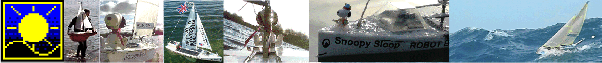
GPS Guided Trans-Atlantic Robot Boat.
If you need "the bigger picture", see Snoopy's front page:
GPS Guided Trans-Atlantic Robot Boat.
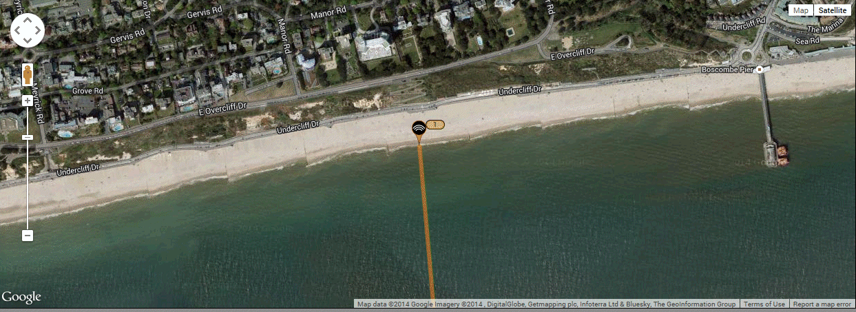
Snoopy made his best attempt yet, to cross the Atlantic at 1045 on Sunday 30th November 2014, from the new launch position, west of Boscombe Pier, instead of Barton-on-Sea. We launched from near the zig-zag steps, seen clearly in the video shot by Dick, wading in before Snoopy ! :-)
It took us the 1.5 hours drive expected, from Sunninghill, to Boscombe Pier, and those interested were able to watch our progress on the SPOT map, which worked, despite the boat being in the car. We had no problem parking near our chosen spot, west of the Pier.
The conditions were perfect for launch, with the expected FLAT surf and offshore wind. The sunshine and mild weather made it a perfect day.
 Most of this page was written in December 2014, about two weeks after the attempt.
It was not until January 2015, that a small fault was found in Snoopy's duplicated solar power supply,
that cast a very different light on why his boat crashed. In short, only half the solar panels
may have been connected, due to corosion, and the main autopilot batteries might have gone flat,
so that Snoopy failed to steer towards the next "Prawle" waypoint. Techinal details were first reported
near the end of the current
Blog on 10th January 2015.
Also, maybe that rudder lever broke BEFORE Snoopy's time on the rocks ?
It was not until 6th February, during 24/7 testing of the repaired boat on Bray Lake, that
yet another fault surfaced, which seems the most likely explanation yet.
The Blog above provides the detail, but Snoopy's ON/OFF switch seems to have failed, into an OFF state,
resulting in the rudder remaing central. Snoopy then sailed in a straight line, at 90 degrees to the wind direction.
If Snoopy's batteries go flat, due to something like a solar panel wiring fault, his rudder tends to adopt
a "hard right" position, which tends to make him drift down wind.
We may never know what happened for sure, but we DO know to check everything !
Italics like this are inserted below.
Most of this page was written in December 2014, about two weeks after the attempt.
It was not until January 2015, that a small fault was found in Snoopy's duplicated solar power supply,
that cast a very different light on why his boat crashed. In short, only half the solar panels
may have been connected, due to corosion, and the main autopilot batteries might have gone flat,
so that Snoopy failed to steer towards the next "Prawle" waypoint. Techinal details were first reported
near the end of the current
Blog on 10th January 2015.
Also, maybe that rudder lever broke BEFORE Snoopy's time on the rocks ?
It was not until 6th February, during 24/7 testing of the repaired boat on Bray Lake, that
yet another fault surfaced, which seems the most likely explanation yet.
The Blog above provides the detail, but Snoopy's ON/OFF switch seems to have failed, into an OFF state,
resulting in the rudder remaing central. Snoopy then sailed in a straight line, at 90 degrees to the wind direction.
If Snoopy's batteries go flat, due to something like a solar panel wiring fault, his rudder tends to adopt
a "hard right" position, which tends to make him drift down wind.
We may never know what happened for sure, but we DO know to check everything !
Italics like this are inserted below.
This section has been added here, since we wish to have Snoopy's Boat 10 as ship-shape as possible, including 24/7 testing for several weeks, before another Atlantic Attempt early in 2015. He already has the next Boat 11, with better electronics, which - after LOTS of testing, should be ready for another attempt, later in 2015. We need to strike the right balance between work on Boat 10 that is essential, and that which might improve his chances of success. Any change, however small, must be properly tested, and testing takes time.
 Bray Lake Tests, a few days after
Snoopy's rescue, were important to us understanding why things had gone wrong.
See the section near the end of this page, "3. Analysis, Testing, and Conclusions", for more detail,
including GPS Plots, showing the effect of an off-set rudder.
Bray Lake Tests, a few days after
Snoopy's rescue, were important to us understanding why things had gone wrong.
See the section near the end of this page, "3. Analysis, Testing, and Conclusions", for more detail,
including GPS Plots, showing the effect of an off-set rudder.
Robin's best guess, less than two weeks after launch, is that we had three problems, that contributed to Snoopy's path, resulting in him having "tide fights" near the coast, then eventually crashing into Portland, near Weymouth:
Snoopy had a significant steering bias to the right, of perhaps 20 or 30 degrees or more, from when he was launched, and was sailing out to his first "Channel" waypoint. When Snoopy turned to head west, towards his "Prawle" waypoint, the bias to the right continued, resulting in him getting too close to the coast, and the stronger tidal currents. He therefore spent hours in "tide fights", first near Swanage, and then just east of Portland Bill.
He eventually got past Portland Bill, and by then the northerly wind had risen to 30mph, and weather helm was probably having as much effect as the offset rudder. i.e. it was making swing towards the north, towards the wind. Snoopy eventually turned eastward, probably the result of the tide, but despite trying to turn hard right*, to head towards "Prawle" to his south west, the weather helm kept him on an eastward course, with Snoopy eventually crashing onto the rocks. * It was in these final hours that the autopilot power may have failed: the batteries being too low for the autopilot to work, and turn the rudder right.
 These are things we must do, or at least seriously consider:
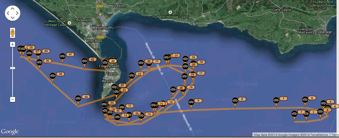
Thanks to Peter, we have this detailed track of Snoopy's path, until he hit the rocks near Portland Bill ...
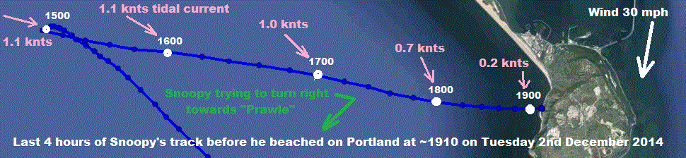
Analysis of the last four hours, before Snoopy hit land, indicate it might have beeen weather helm, caused by the navigation light at the rear. Or just Snoopy's on/off switch failing ? :-)
Robin forgot the sails ?
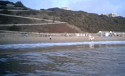
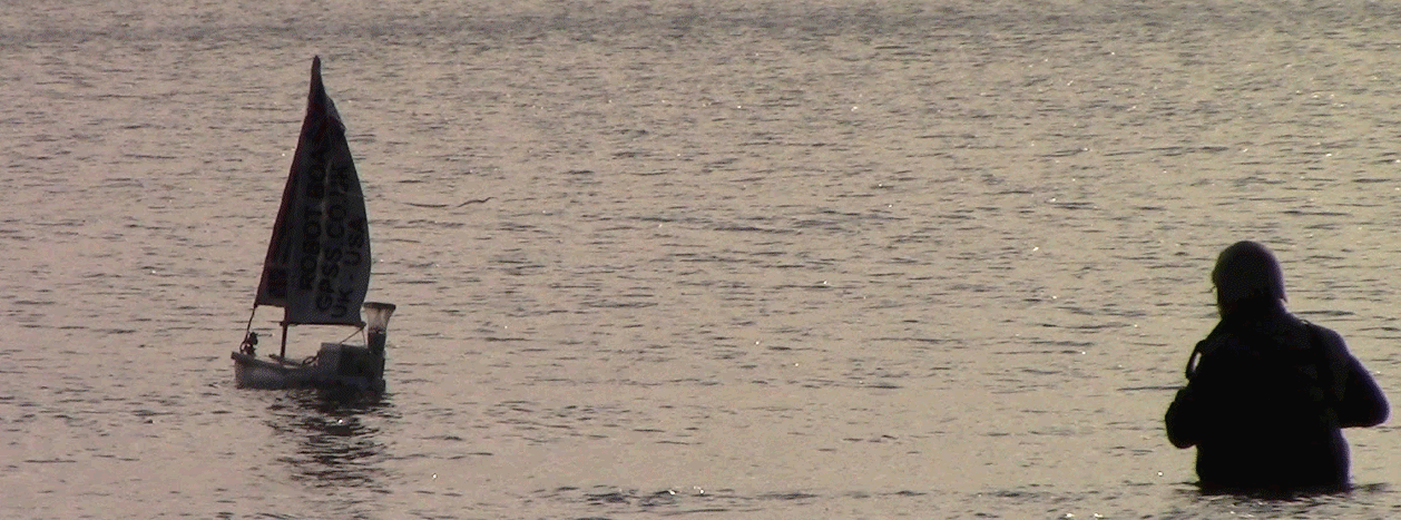
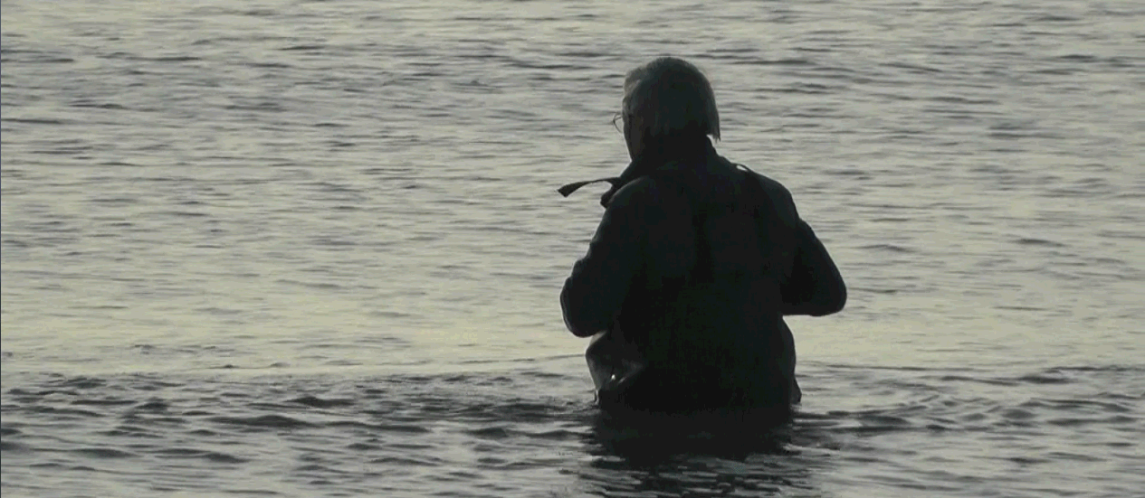
Walking down to the sea: Dick in the water, and Peter on the groin ...
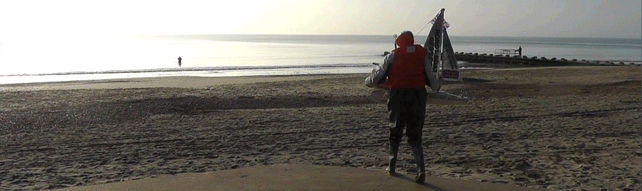
Bon Voyage Snoopy !
That way Snoopy ! :-)
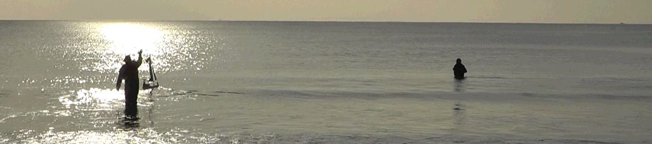
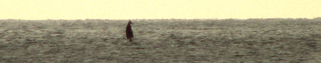
Here is Snoopy, sailing past Dick, standing in the water ! Boscome Pier is in the background. Snoopy is on his way ! :-)
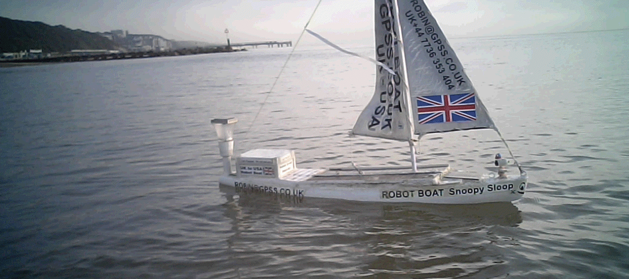
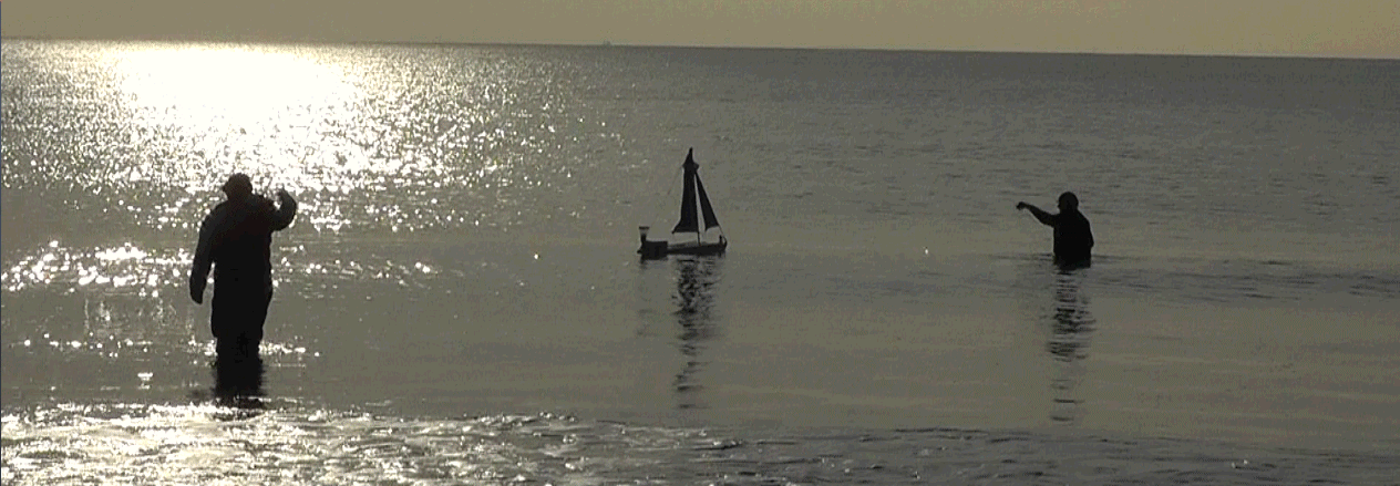
Snoopy catches the wind, and heads out to sea ...
The launch from west of Boscombe Pier, at 1045, as reported by the SPOT tracking system ...
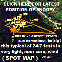
Bray Lake testing has started again, and Snoopy will use this Boat 10, for another attempt in early 2015 ! :-)
Dick watches Snoopy sail away !
Snoopy sails away, watched by telescope and Peter's telephoto camera ...
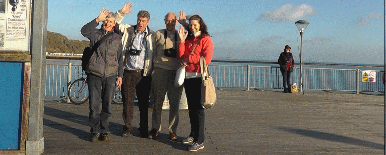
Snoopy's Launch Team, relaxing on Boscombe Pier : Dick, Robin, Peter, and June.
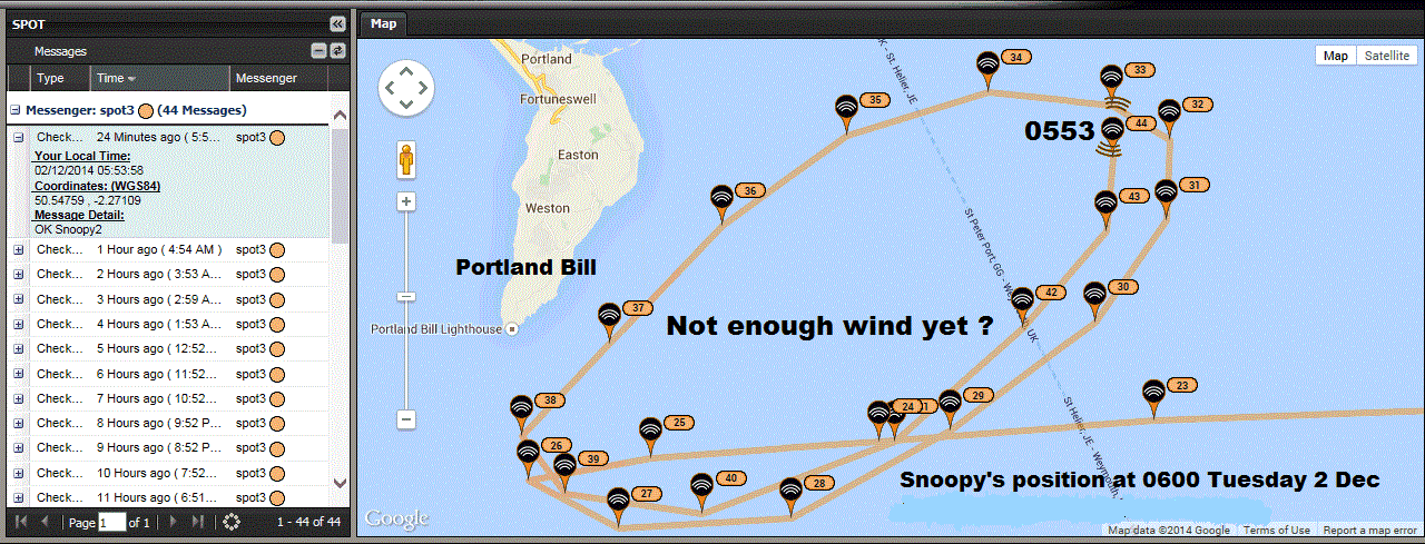
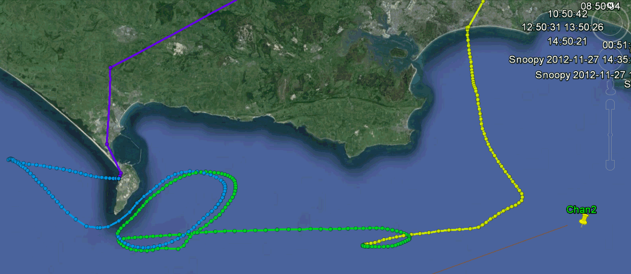
Here is a SPOT Map image, from Monday. After Snoopy's Swanage "Tide Fight" he started a bigger one near Portland Bill. Strong tidal current and wind dropping !
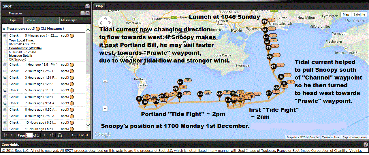
Snoopy needs to sail faster than the tidal current, to win a "Tide Fight". He is not helped when the wind drops : particularly when the tide is as strong, as near Portland Bill !
More to be added here, as the story develops. e.g. will Snoopy get past Portland Bill before midday today ? :-)
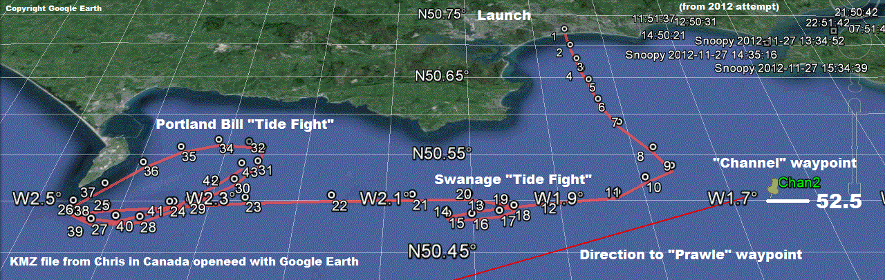
Thanks to Chris in Canada, who sent me a KML file, to open with Google Earth. We can then zoom in on any part of Snoopy's path. You can see how the tide helped Snoopy take a short-cut, rather than sail all the way to his "Channel" waypoint. You can also see that Snoopy is steering to the right of his intended direction. We don't know why yet, but it is no big problem, because Snoopy regularly re-calculates the direction to aim, so he should "curve in" to the correct destination, as he gets closer. Just like on Bray Lake when his rudder was not central :-) I say "no big problem" - if Snoopy does not bump into the land. Next year's autopilot software will squeezee in an extra "intermediate" waypoint, well south of Portland Bill, to reduce the risk of that problem ! It will also reduce the risk of this big "tide fight" that creates such a big delay. Hopefull Snoopy will get past Portland Bill before midday today.
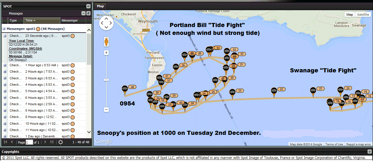
Snoopy has already spent many hours in a major "Tide Fight" near Portland Bill. This was not helped by the wind dropping. His elliptical path was due to the strong tidal current. Let us hope that Snoopy does not bump into land. As I said earlier: The maximum tidal current speed is much less across to Prawle Point, and should not slow him down again until late this afternoon. The wind speed is also expected to increase. At about 5pm (1700) today, the maximum speed of the tide against Snoopy should only be 0.7 knots, compared with over 3 knots near Portland Bill ! Snoopy has the tide helping him, until slack water, at about 1pm (1300), when it changes direction, from westward to eastward again. Winds today are expected to be from North, at over 23 mph, gusting to 40 mph ! If Snoopy has got past Portland Bill, he may make good speed towards Prawle, without another serious "Tide Fight" - but now he must survive a gale ! :-)
Snoopy eventually gets past Portland Bill, and should head for Prawle ...
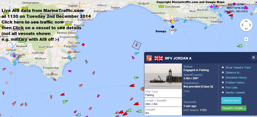
Here's is data from MarineTraffic.com which we discovered after the 2012 attempt. It did not show Royal Marine Landing Craft, but they did show on our cameras, following Snoopy :-) We've used this to plan Snoopy's route, to avoid the busiest parts of the shipping lanes. Now we can use it to watch for Snoopy being snagged by fishermens nets :-)
Why is Snoopy heading in a straight line towards Lyme Regis ? It should be towards Prawle Point ? Surely not a bug in the autopilot software ?
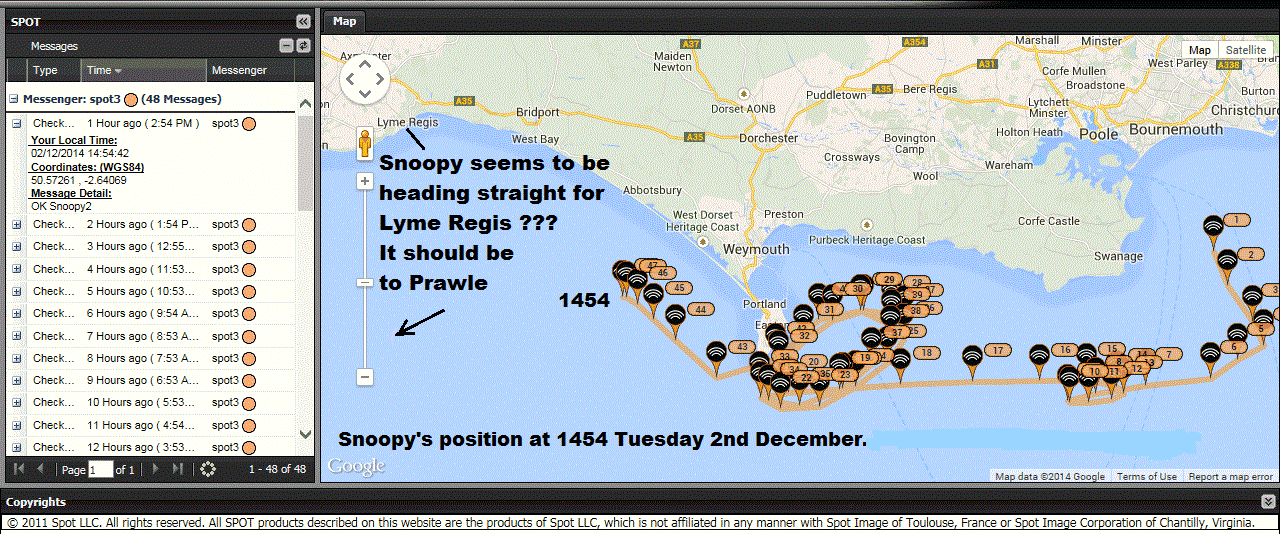
What we said then: In the past few hours, Snoopy was sailing straight, but towards Lyme Regis. That's when we put up the link to the Lyme Regis Web Cam - in case Snoopy had "hitched a lift" :-) "Human Intervention" (accidental or otherwise) now seems unlikely, because Snoopy is not moving at a steady speed - unlike in 2012 ! He seems to be slowing up as the tidal current strengthens against him, and we expect him to be swept back towards Portland Bill. The GPS simulator was used, this afternoon, to check the software steers correctly - towards "Prawle" - and it does. We will have to continue watching, to give us clues on the reason, such as the rudder having twisted off-centre.
Robin runs the GPS Simulator at home, to confirm Snoopy's autopilot software steers the correct way to Prawle near that bit of coast. It does ! :-)
What we said under "Latest News" about now: Earlier we thought maybe Snoopy's strange behaviour was due to his jib (front sail) breaking ? That would make him turn north, towards the wind. i.e. "weather helm". We will see soon ! In the past few hours, Snoopy was sailing straight, but towards Lyme Regis. That's when we put up the link to the Lyme Regis Web Cam - in case Snoopy had "hitched a lift" :-) "Human Intervention" (accidental or otherwise) now seems unlikely, because Snoopy is not moving at a steady speed - unlike in 2012 ! He seems to be slowing up as the tidal current strengthens against him, and we expect him to be swept back towards Portland Bill. The GPS simulator was used, this afternoon, to check the software steers correctly - towards "Prawle" - and it does. We will have to continue watching, to give us clues on the reason, such as the rudder having twisted off-centre. Snoopy has already spent many hours in a major "Tide Fight" near Portland Bill. This was not helped by the wind dropping. His elliptical path was due to the strong tidal current. Let us hope that Snoopy does not bump into land. As I said earlier: The maximum tidal current speed is much less across to Prawle Point, and should not slow him down again until late this afternoon. The wind speed is also expected to increase. At about 5pm (1700) today, the maximum speed of the tide against Snoopy should only be 0.7 knots, compared with over 3 knots near Portland Bill ! Snoopy has the tide helping him, until slack water, at about 1pm (1300), when it changes direction, from westward to eastward again. Winds today are expected to be from North, at over 23 mph, gusting to 40 mph ! If Snoopy has got past Portland Bill, he may make good speed towards Prawle, without another serious "Tide Fight" - but now he must survive a gale ! :-)
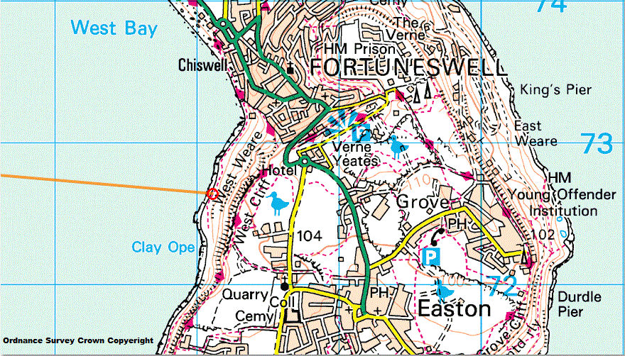
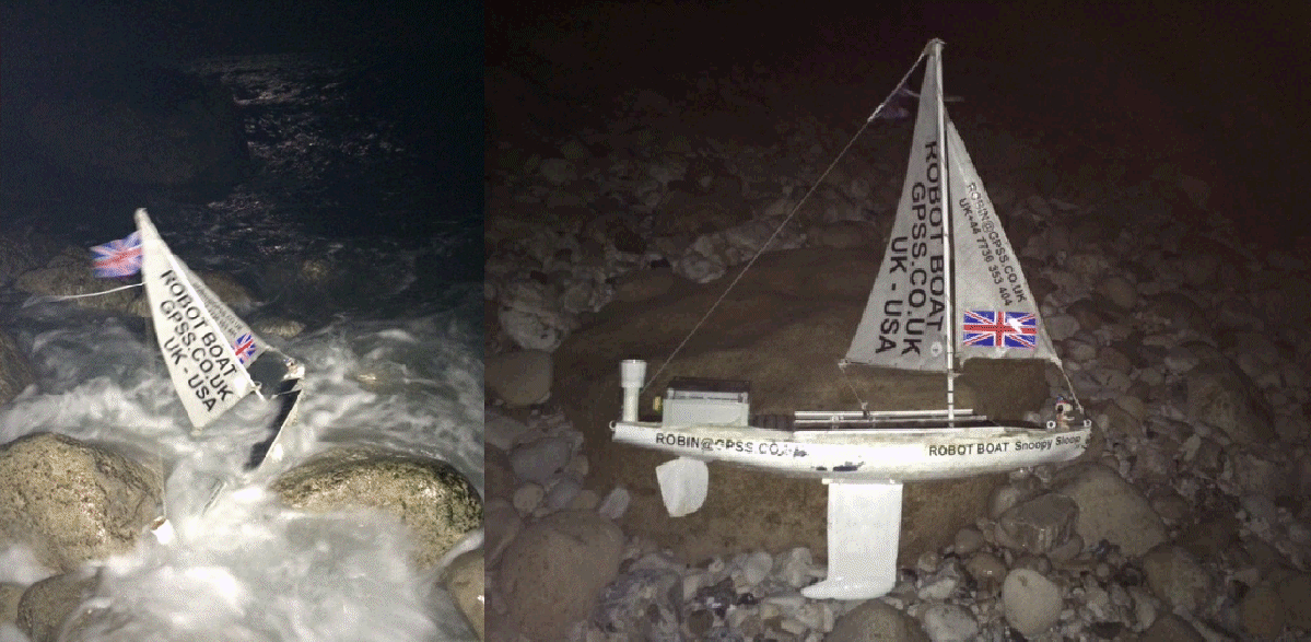
The last part of Snoopy's adventure: eventually landing at the end of Chesil Beach, on Portland ...
Thanks to Peter: Snoopy's landing on Portland Bill, on UK Ordnance Survey mapping: useful if you need to find a footpath to the beach ! :-)
Google Map StreetView, on the beach, looking towards Snoopy's landing spot ...
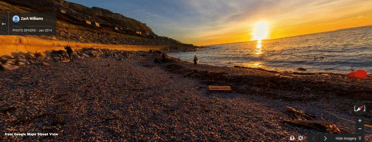
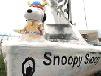
Dick reached the spot at 0127 Wednesday, and found Snoopy with waves splashing around him. He was pulled out of the water. Well Done Dick ! :-)
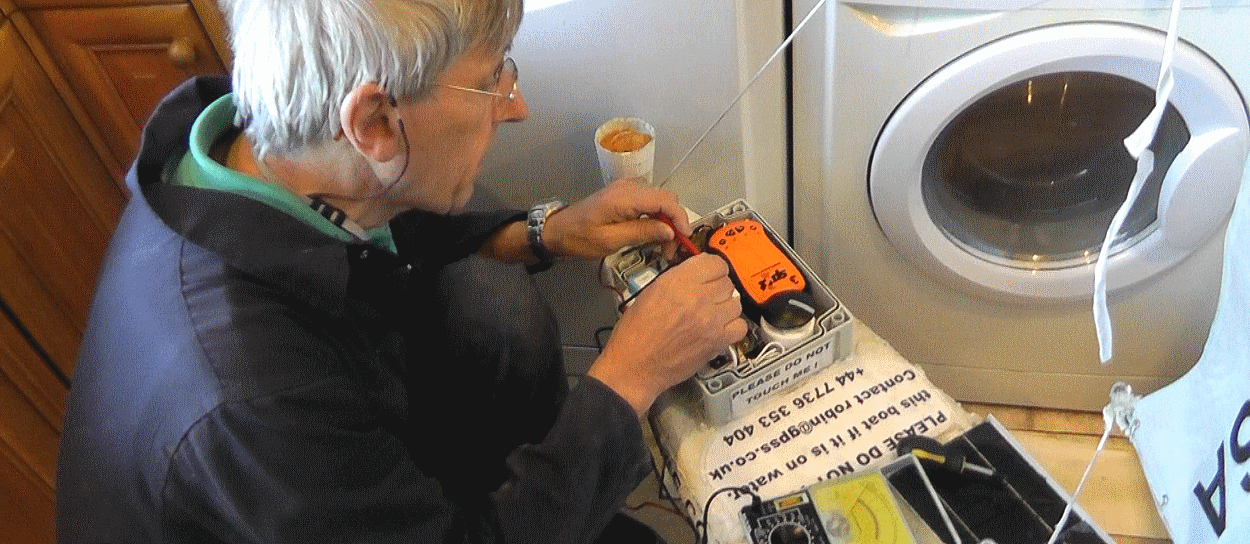
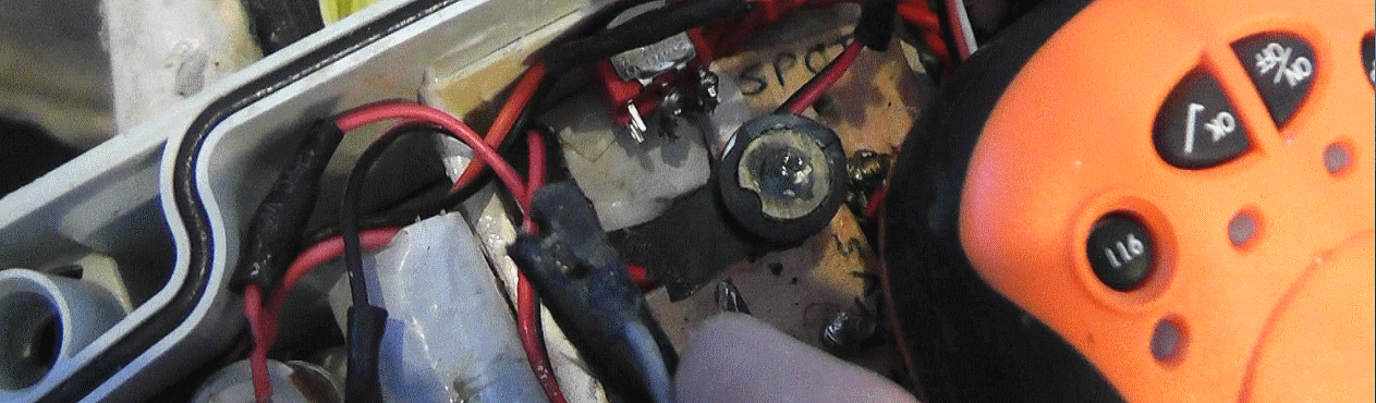
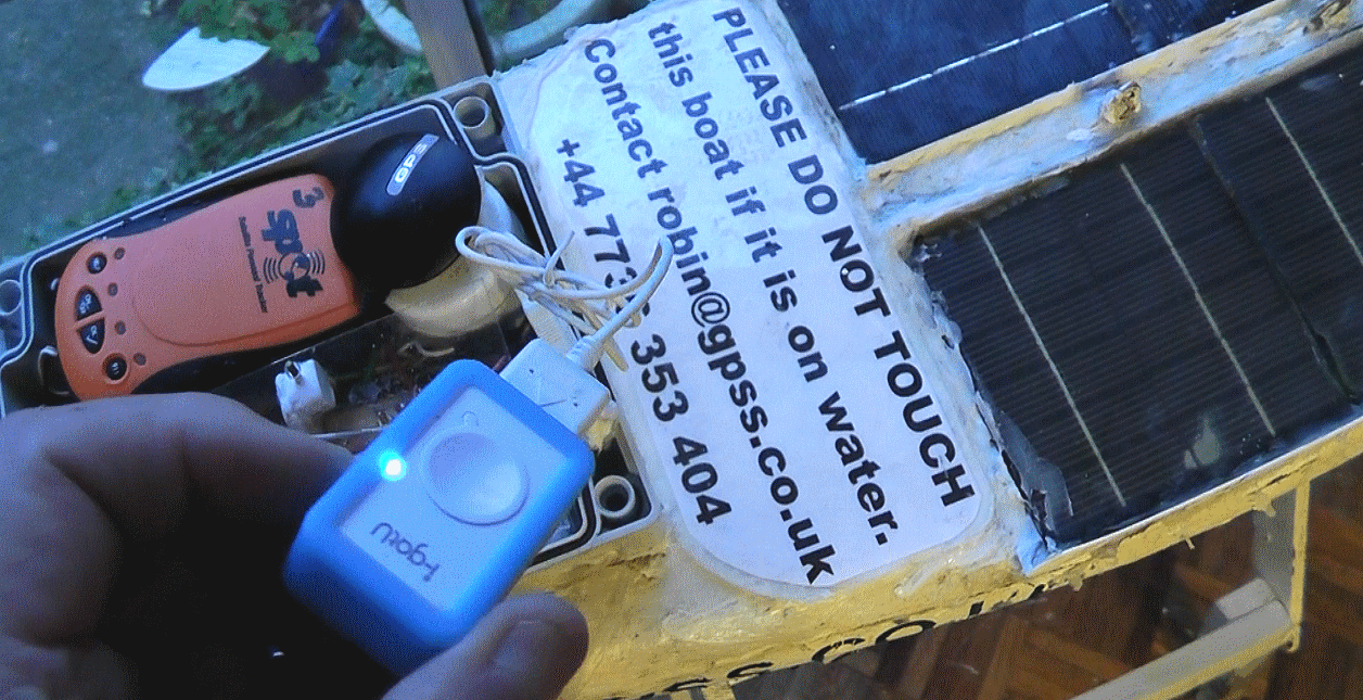
Dick, in his kitchen, checks the battery voltage on the autopilot .... flat - probably after hours on the rocks with a stalled rudder servo ! Easy to recharge batteries :-)
The servo linkage lever on the rudder had broken - that time on the rocks ! Easily replaced. The locktight was still solid :-)
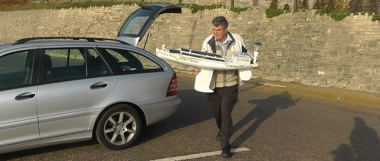
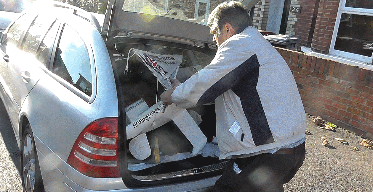
Robin squeezes Snoopy into the back of his car - only possible with mast and sails removed !
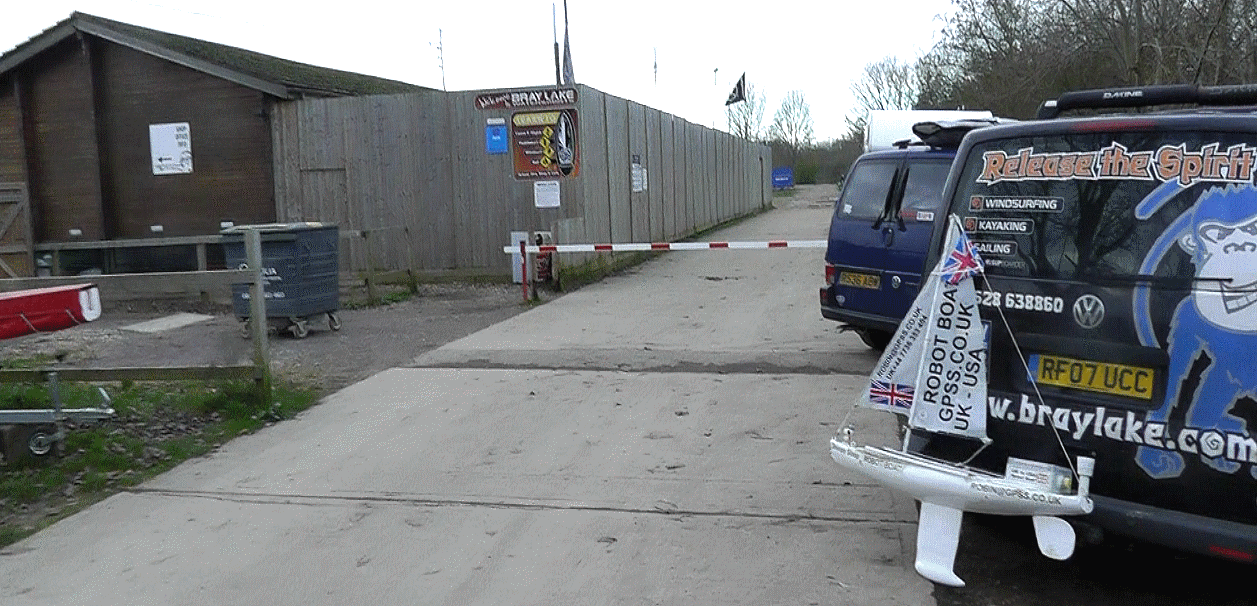
A diversion to Bray Lake on the way from Dick's house in Reading to Robin's in Sunninghill ....
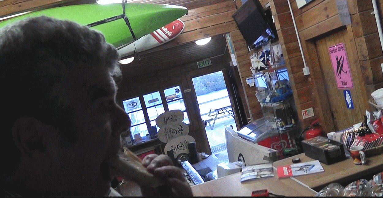
To have some lunch and a chat with experts in the Bray Lakee Watersports Clubhouse ....
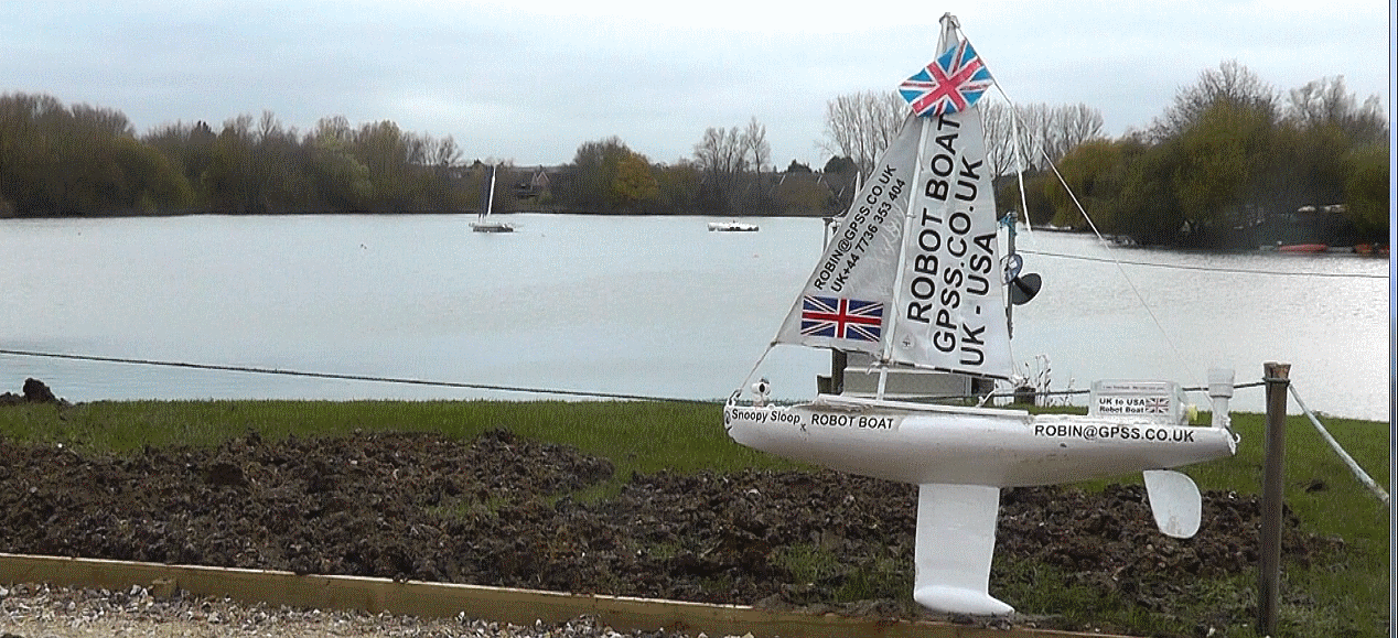
... while Snoopy waits outside, contemplating tests he will need to undertake next week ! :-)
Back at Robin's home in Sunninghill, we check the data from the I-GotU data logger - still running OK ...
Data from the I-GotU GPS Logger, that records data every 12 minutes, instead of the hourly reports from SPOT. This will help us analyse what went wrong.
Bray Lake Test on 27th October, described in our Current Blog. Maybe the boat needed adjustment after that keel repair: see that steering bias !
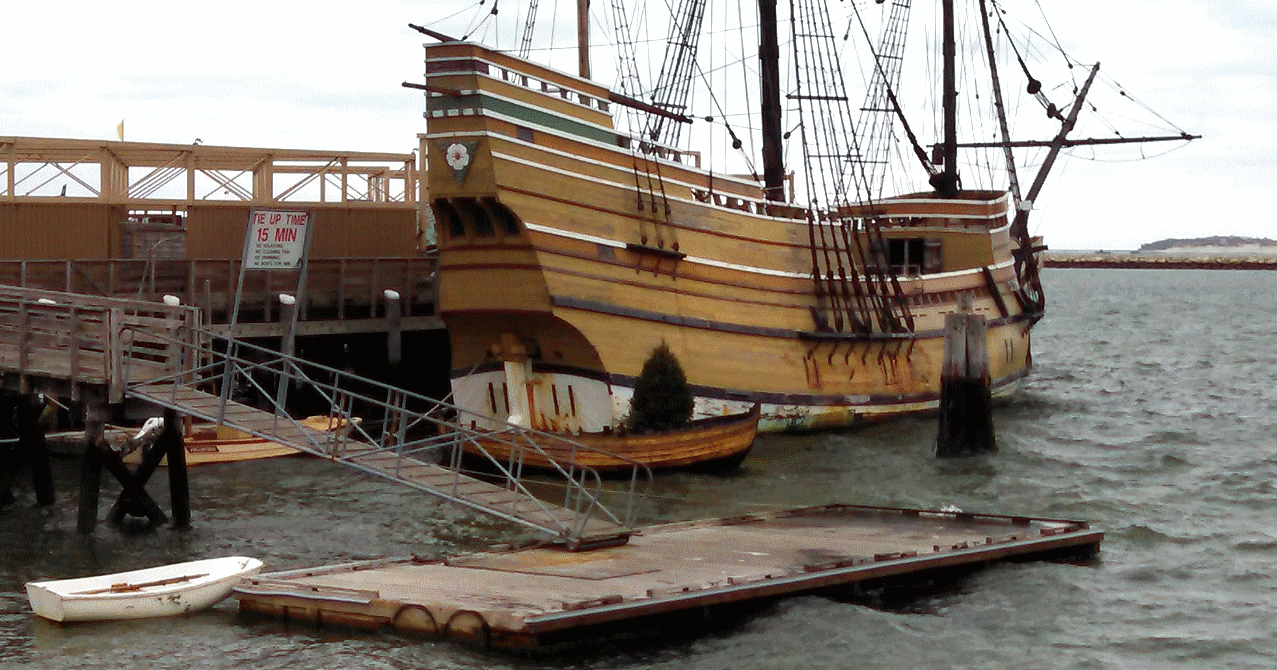
This photo below, taken in the past 24 hours, arrived in my emails this morning, 4th December, from Andy, in Plymouth,MA,USA.
He first contacted me
back in 2012, after their local paper had printed an article about Snoopy, about to make his first Trans-Atlantic attempt.
This was after
Jasper Coppings article in the Sunday Telegraph
, a UK national newspaper, the Sunday before the 2012 launch.
Some of you may recognise this as Mayflower II,
that has appeared in our little animated robot boat picture, on the right, for years, and also on the GPS Simulation video, tucked away
on our "design" and "software" pages. The older picture was taken by neighbours of ours, who - by coincidence - had visited
the Mayflower earlier in 2012.
In his article, Jasper said,
"... to land near the spot where the Pilgrim Fathers came ashore at Plymouth, Massachusetts".
My official response has always been,
"You might say that, but I could not possibly comment." :-)
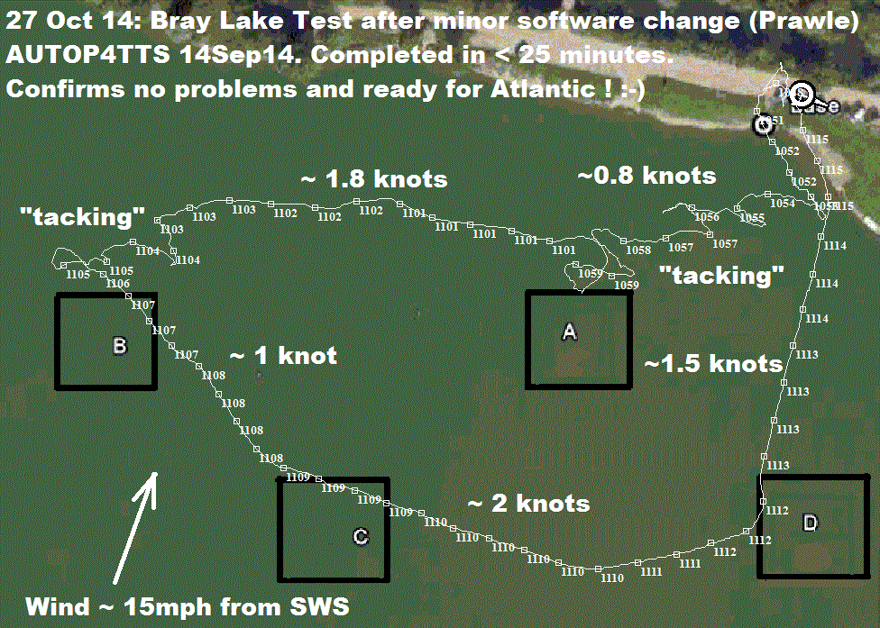
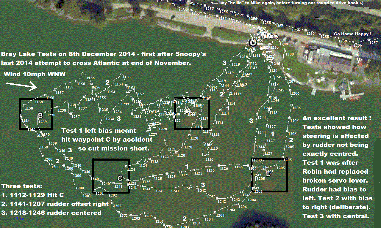 We had an excellent session at Bray Lake on 8th December, resulting in us having a good clue on why Snoopy
tended to steer to the right early in his
Atlantic attempt. This had resulted in him going too close to Portland Bill, and the strong tidal current.
It seems that his rudder may not have been completely central, but had a slight bias to the right.
Click on the GPS plots on the left to read the details. The three tests show that a few degreees of rudder offset
can have a big effect.
We had an excellent session at Bray Lake on 8th December, resulting in us having a good clue on why Snoopy
tended to steer to the right early in his
Atlantic attempt. This had resulted in him going too close to Portland Bill, and the strong tidal current.
It seems that his rudder may not have been completely central, but had a slight bias to the right.
Click on the GPS plots on the left to read the details. The three tests show that a few degreees of rudder offset
can have a big effect.
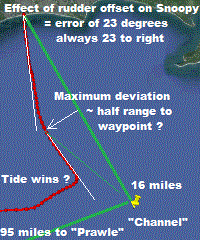
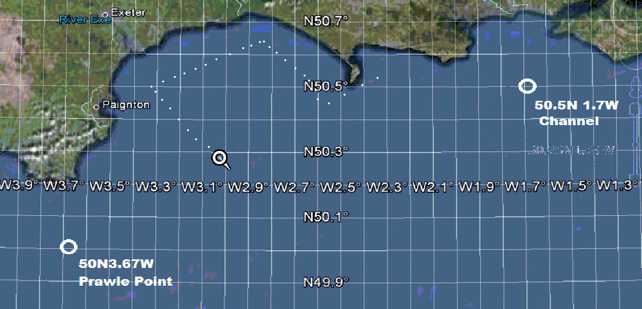
On the right is an analysis of what the size of this error was at the time of Snoopy's last attempt. It seems he was always moving about 23 degreees to the right of his intended direction to the "Channel" waypoint. As Snoopy gets closer, his path "curves" onto the waypoint. We often observe this on Bray Lake plots. The maximum deviation from the straight line route, seems to be in the ballpark of 50% of the range. i.e, 8 miles off, for the "Channel" waypoint 16 miles out - but over 40 miles if aiming for "Prawle" at a range of 95 miles. If we use an Intermediate "Weymouth" waypoint, well south of Portland, there should be much less risk of Snoopy approaching the coast, and stronger tidal current, than if to "Prawle".
 We now understand why Snoopy took a particular path after launch, intending to reach his "Channel" waypoint.
Click on Snoopy's track, on the left, to read the details. Part of our understanding: how the tide effects
Snoopy, is already explained on our
Q&A page.
Smoopy made good progress, after launch, for the first two hours,
up until about 1400, moving in a straight line, but with that "rudder-offset" error, to the right.
The tidal current increased, and - as expected - his progress was slower, because he was steering to the
right more, to compensate for the tide. The tide slackened, and so he made faster progress for three
hours aiming for his "Channel" waypoint. By 1800, the tidal current was increasing speed again, flowing
towards the west, and by 1900, had "won", because it's speed was faster than Snoopy was sailing
through the water. Snoopy was still aiming for the "Channel" waypoint, but was unable to overcome the tide.
However, at about 2100, the tide had carried Snoopy south of the 50 30'N line (Latitude 50.5 degrees),
used by his autopilot to switch to the "Prawle" waypoint, to his west. He therefore made good progress
towards his next waypoint, helped by the tide, but with the same rudder-offset error to the right.
This offset error, combined with the early turn, made his "tide fight" the next day, more probable:
tidal current is stronger near the coast. Two things might have avoided this "tide fight":
1) a closer waypoint, south of Weymouth; 2) having a straight rudder ! :-)
We now understand why Snoopy took a particular path after launch, intending to reach his "Channel" waypoint.
Click on Snoopy's track, on the left, to read the details. Part of our understanding: how the tide effects
Snoopy, is already explained on our
Q&A page.
Smoopy made good progress, after launch, for the first two hours,
up until about 1400, moving in a straight line, but with that "rudder-offset" error, to the right.
The tidal current increased, and - as expected - his progress was slower, because he was steering to the
right more, to compensate for the tide. The tide slackened, and so he made faster progress for three
hours aiming for his "Channel" waypoint. By 1800, the tidal current was increasing speed again, flowing
towards the west, and by 1900, had "won", because it's speed was faster than Snoopy was sailing
through the water. Snoopy was still aiming for the "Channel" waypoint, but was unable to overcome the tide.
However, at about 2100, the tide had carried Snoopy south of the 50 30'N line (Latitude 50.5 degrees),
used by his autopilot to switch to the "Prawle" waypoint, to his west. He therefore made good progress
towards his next waypoint, helped by the tide, but with the same rudder-offset error to the right.
This offset error, combined with the early turn, made his "tide fight" the next day, more probable:
tidal current is stronger near the coast. Two things might have avoided this "tide fight":
1) a closer waypoint, south of Weymouth; 2) having a straight rudder ! :-)
Also there is the question of weather helm - which may come into play in strong winds of 30 mph, due to wind on the rear navigation lamp and box. Below, you see what looks like compelling evidence that Snoopy was suffering from weather helm.
Things look good for Snoopy being ready to sail again, in this same Boat 10, early next year. Minor repairs will be made, to things like chips, scratched paint, and the rudder centre position ! If weather helm is confirmed, a skeg will be added to modify the sailing balance of the boat. The software has already been modified, to add another waypoint 13 miles south of Portland Bill - to keep him well away from there ! :-)
These are words and pictures that were under "Latest News" on Snoopy's "Front Page" ....
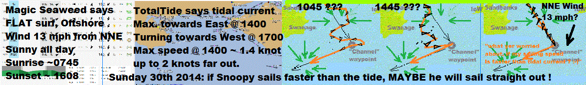
 We watch
Magic Seaweed
- for a dry day, with FLAT surf, and an offshore wind.
We watch
Magic Seaweed
- for a dry day, with FLAT surf, and an offshore wind.
See
Snoopy's Earlier Aborted November 2014 Attempt Page
and the
Video
.
See
Snoopy's Earlier 6th September 2014 Attempt, for that story in pictures, then
play the Video.
Snoopy will try again, this Sunday 30th, launching at 1045, from near Boscombe Pier. Watch the SPOT map to see us on our way from home, down the M3. There is an outside chance that you may glimpse Snoopy's sailing out on the Boscombe Web Cam within the first hour after launch. We watch MagicSeaweed for FLAT surf, an off-shore wind, and no rain. We also double-check wind direction on Winds Expected. We plan to launch from near Bournemouth, west of Boscombe Pier , and exploit knowledge of how the boat behaves with wind and tide.
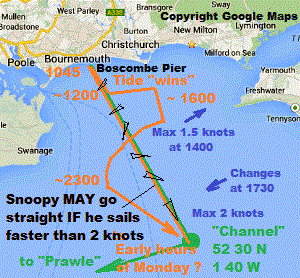
On the left is Robin's best guess on what MAY happen, if Snoopy gets away from the shore, and conditions
are what we expect. If Snoopy sails faster than the tidal current, which means faster than up to 2 knots,
he may manage to reach his "Channel" waypoint, in a perfectly straight line.
 If we can still see him,
a mile or two out, where the current is stronger, we should see him steering to our right - towards the west
- compensating for the eastward flowing current. It is quite probable, that when the tidal current is strongest,
around 1400 (to east) and 2000 (to west), Snoopy will be carried by the tide. But when "slack water" approaches,
as the current changes direction, he should manage to sail directly towards his "Channel" waypoint again.
Whatever happens, Robin's best guess is that Snoopy will arrive at the waypoint, 15 miles south of Barton,
in the early hours of Monday. He should then turn, and head towards the west, and his next "Prawle" waypoint.
Of course, you can all watch this on the SPOT map, if you don't need to get up to go to work in the morning !
Or maybe you are on the other side of the "Pond", in USA, so this is all happening a few hours later for you :-)
If we can still see him,
a mile or two out, where the current is stronger, we should see him steering to our right - towards the west
- compensating for the eastward flowing current. It is quite probable, that when the tidal current is strongest,
around 1400 (to east) and 2000 (to west), Snoopy will be carried by the tide. But when "slack water" approaches,
as the current changes direction, he should manage to sail directly towards his "Channel" waypoint again.
Whatever happens, Robin's best guess is that Snoopy will arrive at the waypoint, 15 miles south of Barton,
in the early hours of Monday. He should then turn, and head towards the west, and his next "Prawle" waypoint.
Of course, you can all watch this on the SPOT map, if you don't need to get up to go to work in the morning !
Or maybe you are on the other side of the "Pond", in USA, so this is all happening a few hours later for you :-)
Snoopy made an attempt at 0830 on Sunday 23rd November, cut short by a software bug which is now fixed. The details are on Snoopy's November 2014 Attempt and there is now a Video. The detail of Snoopy's preperation for this attempt, and correction then testing of the software, is in the current Blog. The Q&A page discusses the effect of a strong tidal flow on robot sailing boats. We have a new Tide Page, as an aid to understanding the best launch time, on a particular day. e.g. three hours ahead of Portsmouth High Water. This is our "Plan A". But what if it gets closer to Christmas, and we still do not have both FLAT surf and offshore breeze ? Could we beat the waves ?
© 1991-2014 Robin Lovelock. Please credit www.gpss.co.uk if you use material from any of these pages. Thankyou.