
Please see
Snoopy's Robot Boat "Q & A" (Questions and Answers) page for background,
including "Do you understand the tide ?" and how robot boats are affected by it.
The following TotalTide images show predicted tidal currents for Saturday 15th November 2014,
every hour, from 0700 to 2300 GMT.
They are © Crown Copyright.
 This page, and the TotalTide images below, were originally created two weeks before this date of 15th November 2014,
when we thought this might be a good day for Snoopy to make his next Atlantic Attempt.
We had early predictions of FLAT surf and strong off-shore wind on
Magic Seaweed
- our main means of predicting a suitable "launch window".
As we got closer to the date, the predictions changed, but this page is still usefull to
illustrate the details of tidal current in our launch area, between Swanage, Bournemouth,
and the Isle-of-Wight. Maybe, with minor changes, this page might become a simple
means of planning a launch time, for any date, to take account of the tide.
This page, and the TotalTide images below, were originally created two weeks before this date of 15th November 2014,
when we thought this might be a good day for Snoopy to make his next Atlantic Attempt.
We had early predictions of FLAT surf and strong off-shore wind on
Magic Seaweed
- our main means of predicting a suitable "launch window".
As we got closer to the date, the predictions changed, but this page is still usefull to
illustrate the details of tidal current in our launch area, between Swanage, Bournemouth,
and the Isle-of-Wight. Maybe, with minor changes, this page might become a simple
means of planning a launch time, for any date, to take account of the tide.
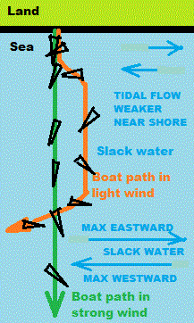
When we get closer to a suitable day for launch, we need to decide the time of launch. We may wish to minimise the risk of the tide sweeping Snoopy eastward, to the even stronger currents near the Isle of Wight ! Our strategy is to launch before "slack water" when the tide is about to turn westward. The tidal current is weaker near the shore, and so maximum benefit will be obtained by launching one or two hours earlier.
Note that this "launch stategy" is to minimise risk of Snoopy being swept eastward by the tide, should the wind be lighter than hoped. With a strong offshore wind, Snoopy should head straight for his "Channel" waypoint, 15 miles out to sea. The "Q & A" page above discusses how our robot boats are affected by strong tidal currents, according to their sailing speed, determined by the wind. There are other things, such as rain, visibility, or hours of darkness, that could be more important in choosing a launch time. Just a few days later, and this strategy would give a launch in darkness !
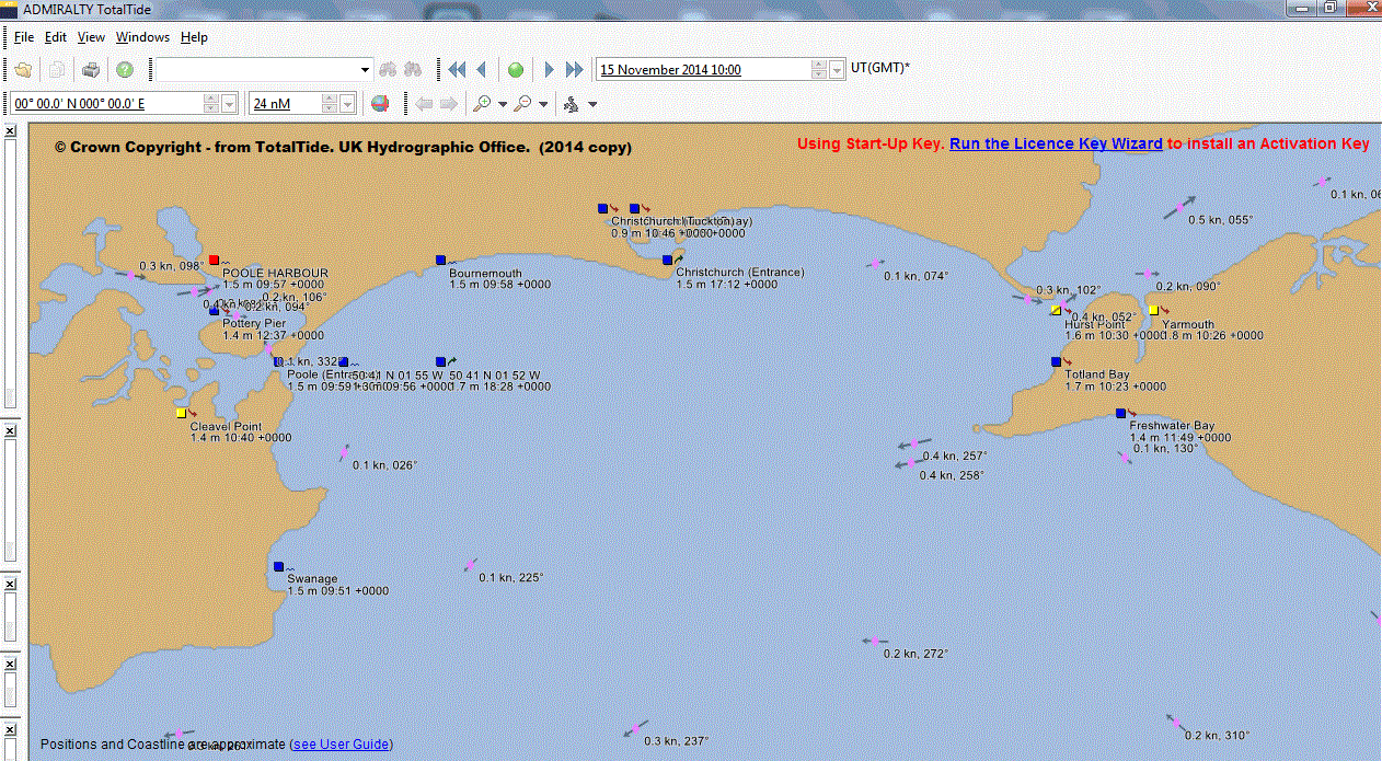
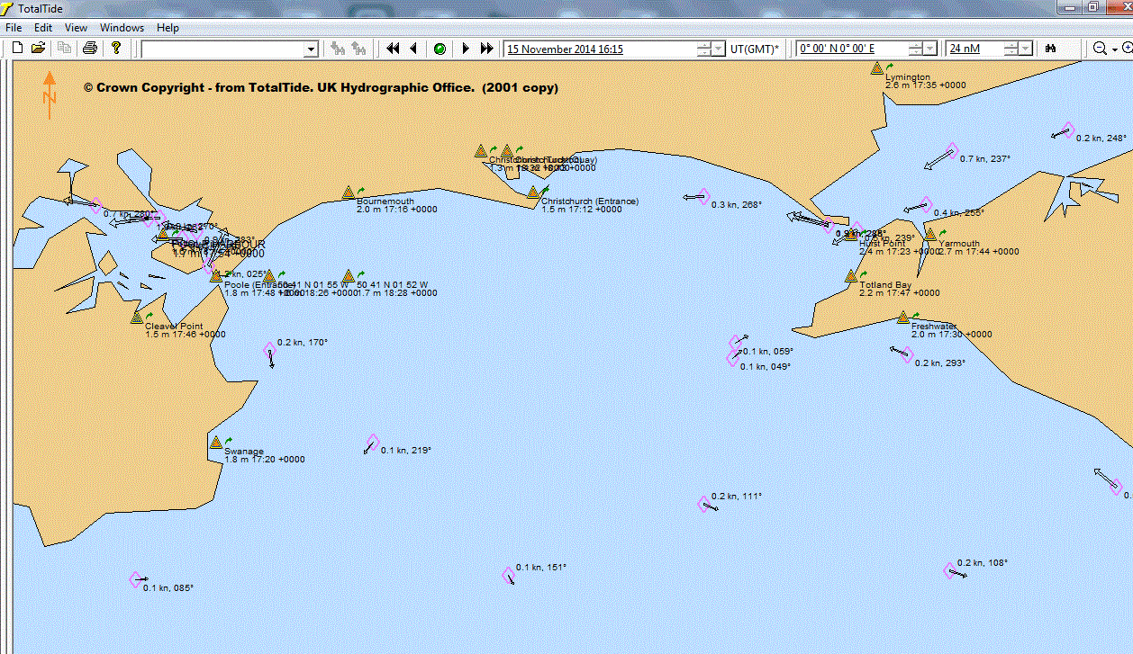
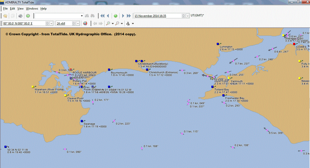
The Totaltide images for the 15th November below, show that this launch time could be at about 1400 - two hours before the tide begins to turn westward. We might modify this to correspond with one of Snoopy's hourly SPOT position reports. e.g. 1350. If we launch then, The boat might take one or two hours, to get away from the coast, and into a much stronger tidal current. By the time it gets that far, the boat is heading into "slack water", that then turns, taking the boat west, and away from the Isle of Wight. Remember: when the boat is sailing faster than the tide, it should sail straight, and not be swept by the tide. See the illustration on the right.
 Most people do NOT have the use of the Totaltide model. Therefore, it could be useful
to relate the launch time to that of "high water", which is much easier to find on the Net.
e.g.
Portsmouth High Water.
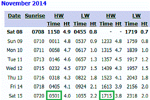
e.g. the times of 0501 or 1715 for High Water at Portsmouth on the 15th.
It seems that, in our launch area, we get "slack water" and the current turns westward, about one
hour before Portsmouth High Water. e.g. See the 1600 chart below.
Most people do NOT have the use of the Totaltide model. Therefore, it could be useful
to relate the launch time to that of "high water", which is much easier to find on the Net.
e.g.
Portsmouth High Water.
e.g. the times of 0501 or 1715 for High Water at Portsmouth on the 15th.
It seems that, in our launch area, we get "slack water" and the current turns westward, about one
hour before Portsmouth High Water. e.g. See the 1600 chart below.
They can then look at tidal charts, relative to this high water time, such as those below, or those on VisitMyHarbour.com. e.g. for 1400 on the 15th, they can look for the chart that says "9 AFTER" (0501) or "3 BEFORE" (1715).
We can simplify our launch strategy down to launching within a particular "time window" of high water. e.g. "9 hours after high water at Portsmouth" or - perhaps more simply - "3 hours before high water at Portsmouth". We would expect the same situation, roughly 12 hours later, but that would be after 0200, in total darkness !
So let's say, "launch 3 hours before Portsmouth High Water", if we want minimise the risk of going east, to the Isle of Wight :-)
Please note that these images below, were produced from an old, 2001 copy of the TotalTide computer model, and we might expect much later versions, or later charts with tidal data, to be more accurate and detailed. e.g. those from VisitMyHarbour.com. However, this old version of TotalTide has seemed to give reliable results, including when we examined GPS Bottle, and Snoopy tracks from earlier attempts, such as September 2014. This includes Snoopy's track in 2012, when we had kind assistance of Hydrographer's Office. I therefore think that they are a useful aid in our planning Snoopy's launch times. I purchased a new copy of TotalTide to compare it's output with the images below. Results are near the bottom of this page: it seems to give almost identical results. If there is any inaccuracy in any TotalTide prediction, judged by looking at GPS tracks, it is in the ballpark of about an hour late. i.e. things happen an hour earlier than the TotalTide predictions. But please check things yourself. I've moved some "Earlier notes" to the bottom of this page, after the Totaltide images, for those interested. They relate to times of high water at Bournemouth, which I now understand to be less relevant.
ROBIN WELCOMES HEARING FROM YOU IF YOU SEE CORRECTIONS THAT NEED TO BE MADE TO THIS PAGE. e.g. labeling of the images below.
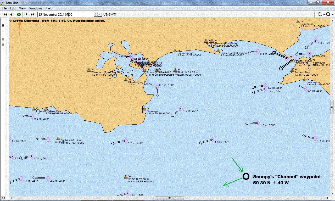
0700 on 15 Oct 2014: 2 hours after
Portsmouth High Water at 0501,
and about 10 hours before
High Water at 1715
:
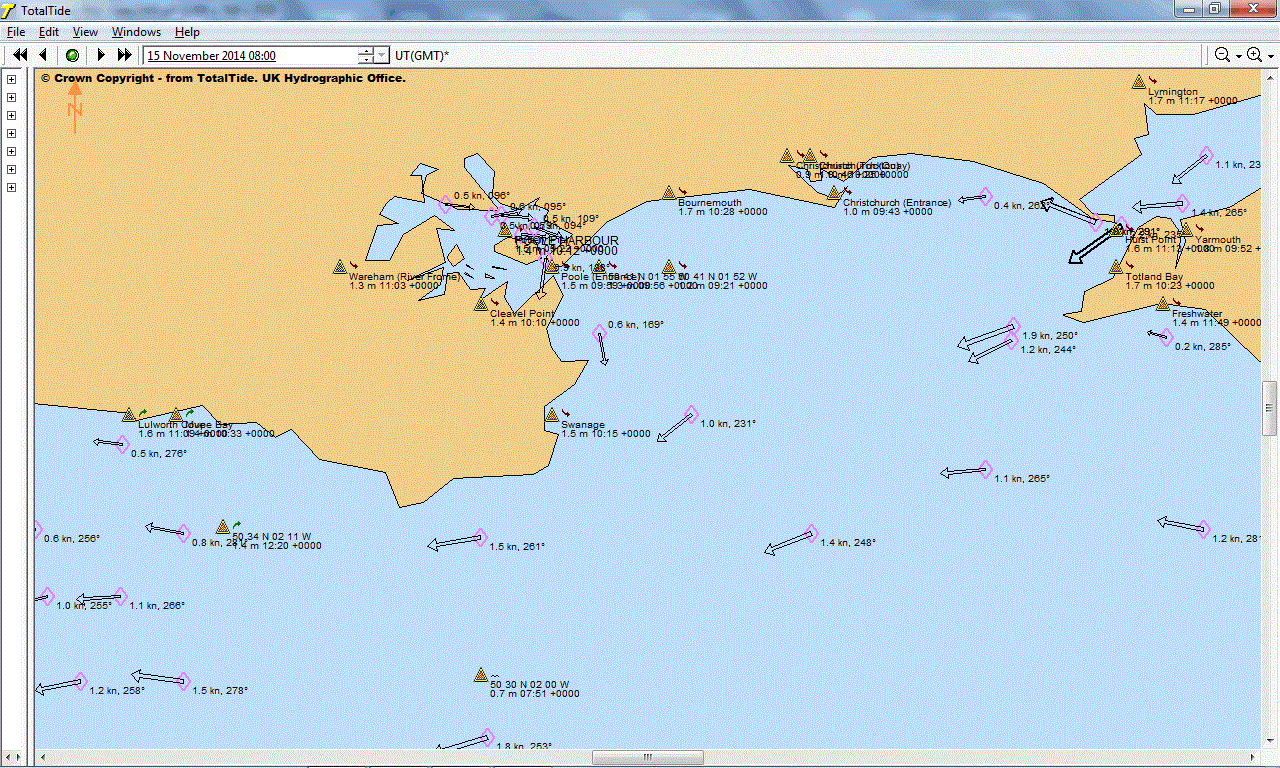
0800 on 15 Oct 2014: 3 hours after
Portsmouth High Water at 0501,
and about 9 hours before
High Water at 1715:
0900 on 15 Oct 2014: 4 hours after
Portsmouth High Water at 0501,
and about 8 hours before
High Water at 1715:
1000 on 15 Oct 2014: 5 hours after
Portsmouth High Water at 0501,
and about 7 hours before
High Water at 1715:
1100 on 15 Oct 2014: 6 hours after
Portsmouth High Water at 0501.
and about 6 hours before
High Water at 1715:
1200 on 15 Oct 2014: 7 hours after
Portsmouth High Water at 0501,
and about 5 hours before
High Water at 1715:
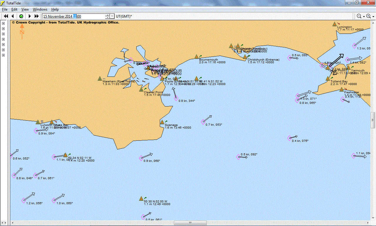
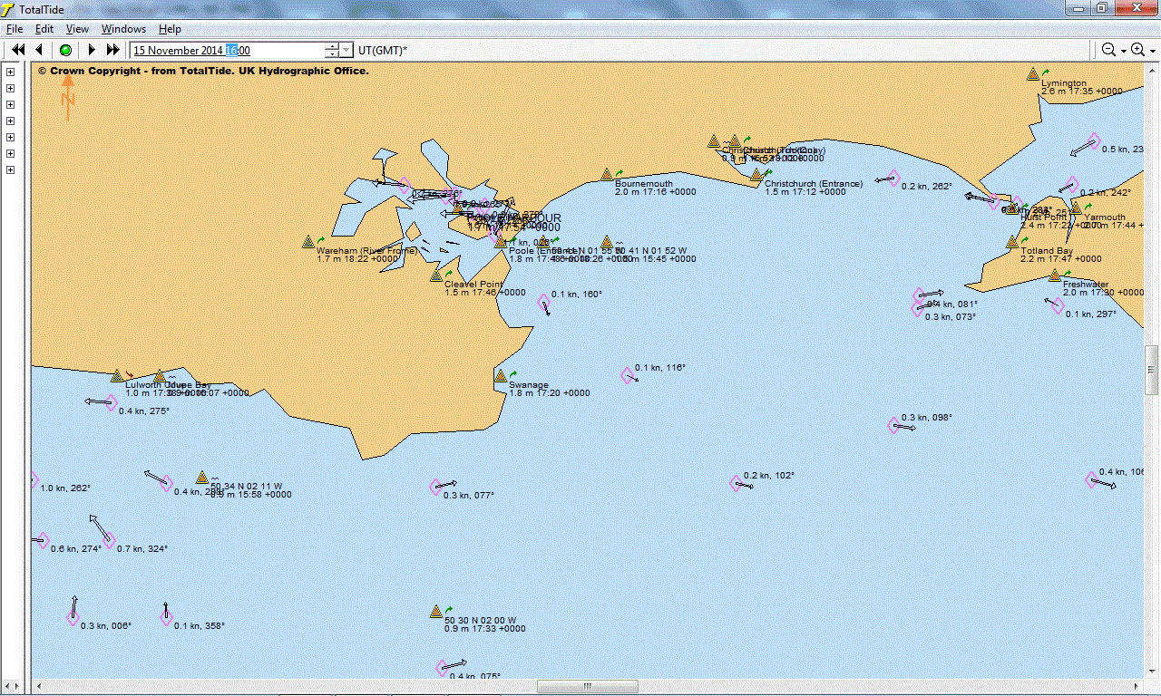
1300 on 15 Oct 2014: 8 hours after
Portsmouth High Water at 0501,
and about 4 hours before
High Water at 1715:
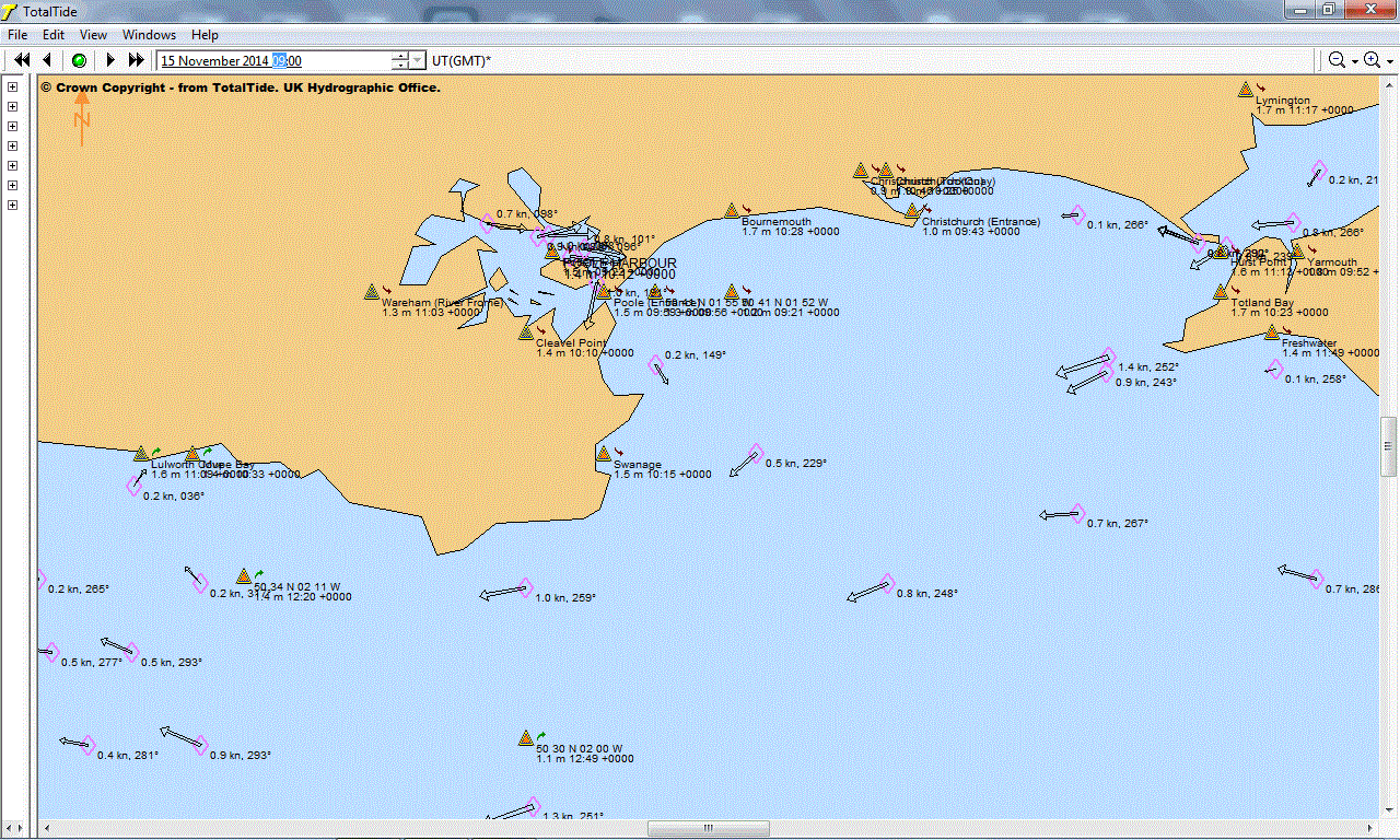
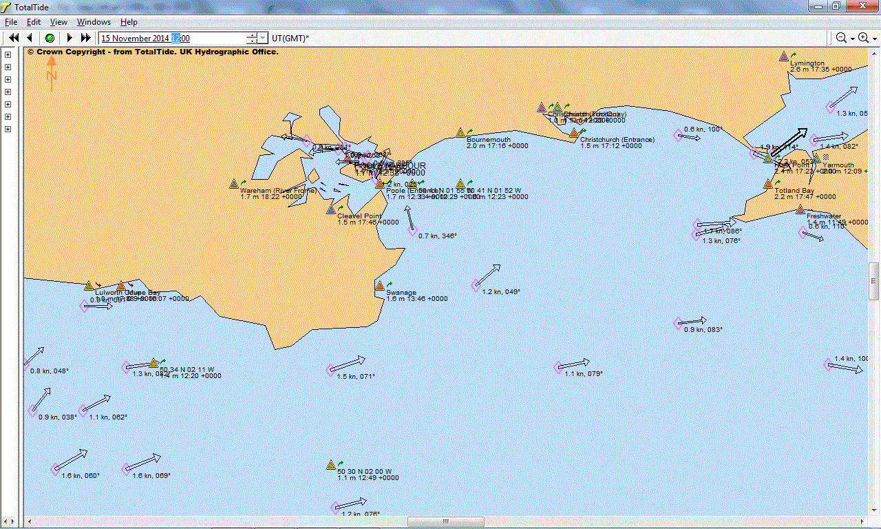
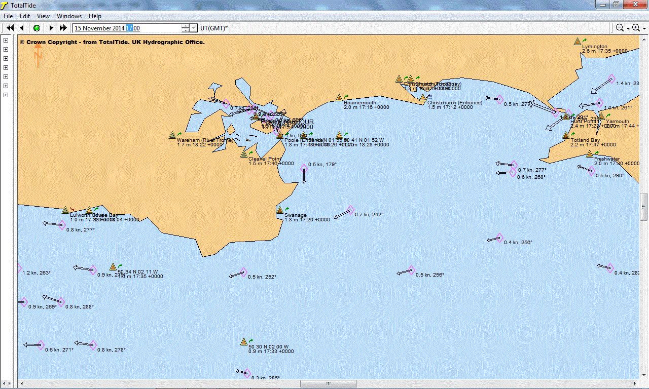
1400 on 15 Oct 2014: 9 hours after
Portsmouth High Water at 0501,
and about 3 hours before
High Water at 1715:

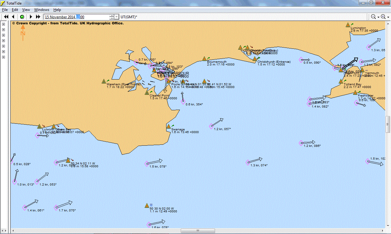
1500 on 15 Oct 2014: 10 hours after
Portsmouth High Water at 0501,
and about 2 hours before
High Water at 1715:
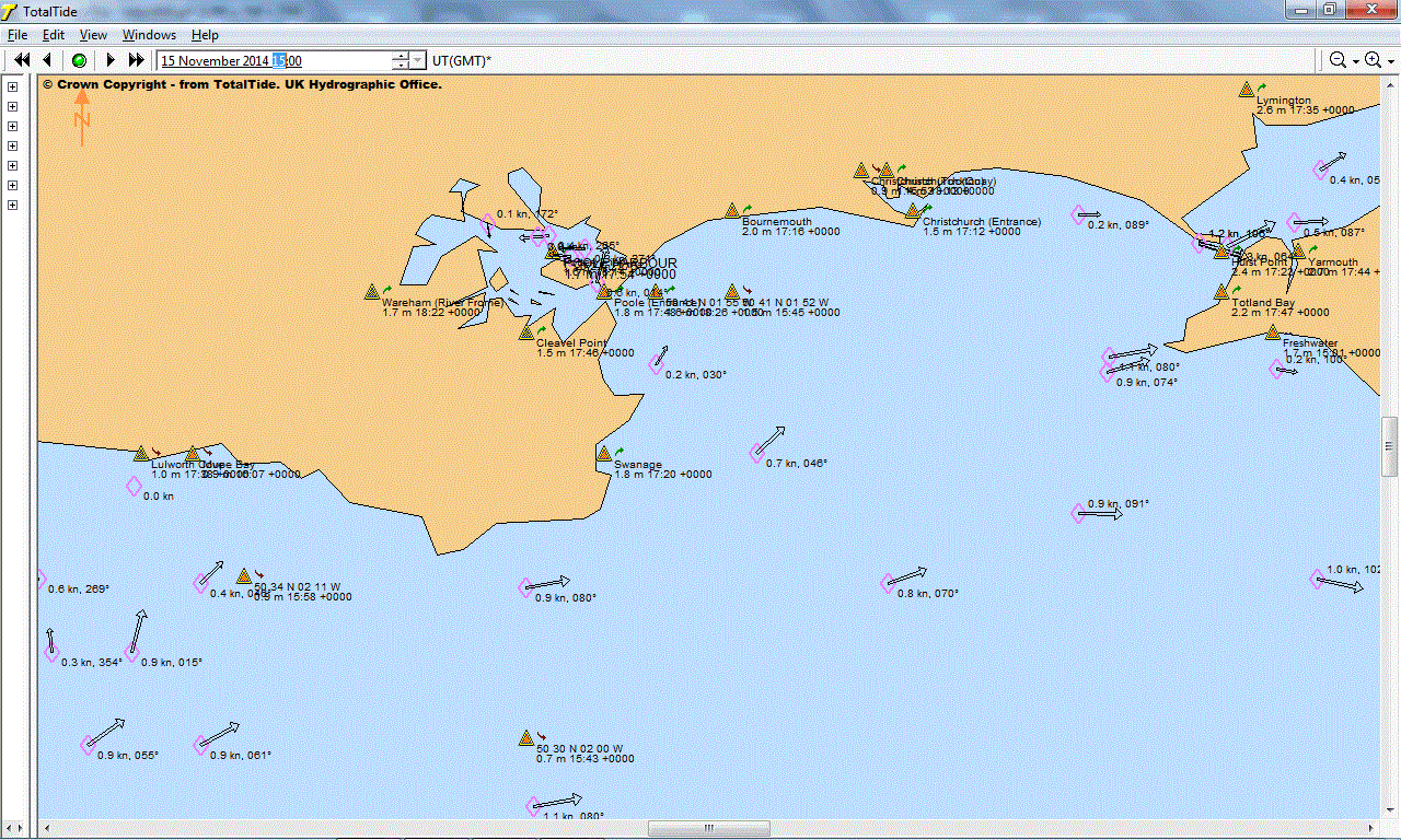
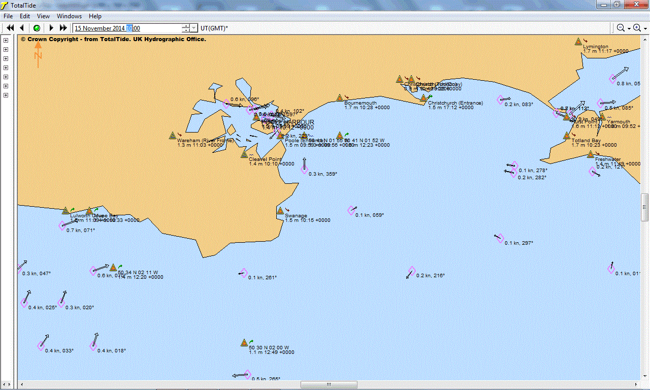
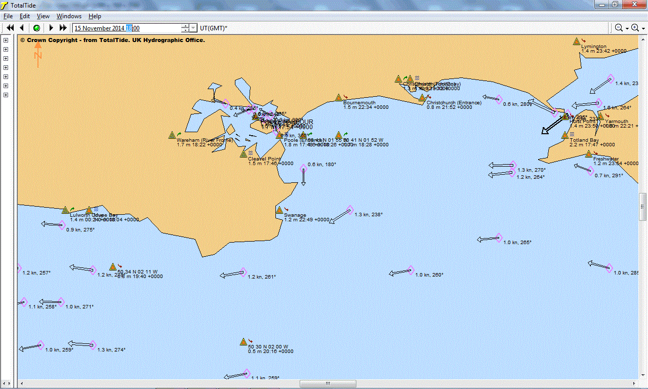
1600 on 15 Oct 2014: 11 hours after
Portsmouth High Water at 0501
, and about 1 hour before
High Water at 1715:
1700 on 15 Oct 2014: 12 hours after
Portsmouth High Water at 0501
, and at (approximate)
High Water at 1715:
1800 on 15 Oct 2014: about 1 hour after
High Water at 1715
:
1900 on 15 Oct 2014: about 2 hours after
High Water at 1715
:
2000 on 15 Oct 2014: about 3 hours after
High Water at 1715
:
2100 on 15 Oct 2014: about 4 hours after
High Water at 1715
:
2200 on 15 Oct 2014: about 5 hours after
High Water at 1715
:
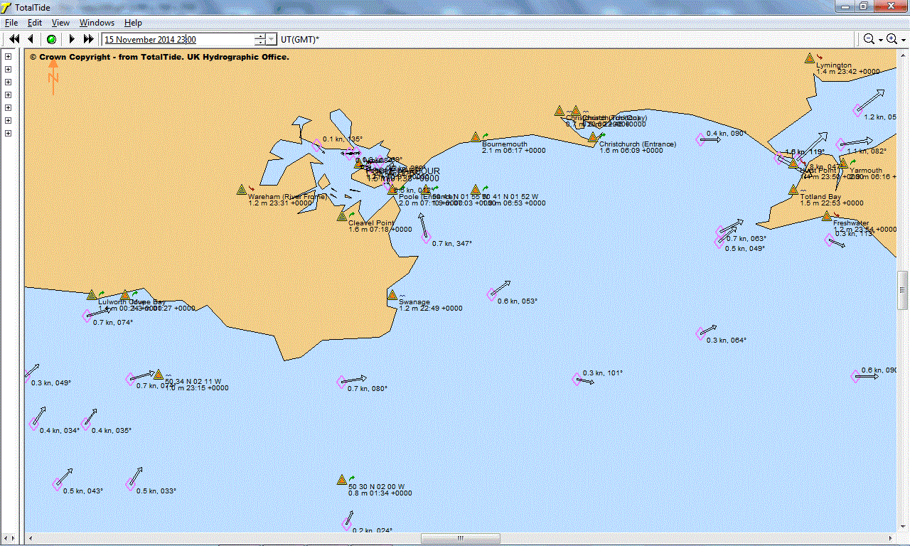
2300 on 15 Oct 2014: about 6 hours after
High Water at 1715
:
Above images are © Crown Copyright - from TotalTide. UK Hydrographic Office.
Having purchased my new copy of Admiralty ADP Totaltide ( at �81 for a 12 months licence), I'm pleased to report that spot checks indicate it gives almost identical predictions as the old 2001 copy, used for the images above. This includes the 1000 prediction below, which you may compare with that above. The time of slack water seeems to be within 15 or 30 minutes. I also confirmed that both versions gave the time of slack water being at about 1545 on 27th November 2012. i.e. no change in my opinion of what happened on that day :-)
I've added two more images below, showing the predictions of time of slack water, before Portsmouth high water at 1715. The old copy of TotalTide predicts this being about an hour earlier - at 1615. The new version of TotalTide predicts it being about 40 minutes earlier. So our assumption of about an hour seems reasonable.
Images below are © Crown Copyright - from TotalTide. UK Hydrographic Office.
1000 on 15 Oct 2014: 3 hours before high water at Bournemouth
, and about 7 hours before
High Water at 1715 (from 2014 copy of Totaltide) :
Prediction time of slack water from old, 2001 copy of TotalTide: 1 hour before Portsmouth High Water at 1715.
Prediction time of slack water from new, 2014 copy of TotalTide: 40 minutes before Portsmouth High Water at 1715.
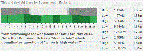 I've move earlier notes down here, for those that are interested. Originally, we thought time of high water
at Bournemouth might be important, but later realised that any manual use of tidal current charts,
relative to high water, would probably use Portsmouth.
The picture on right was from
www.magicseaweed.com
for Highcliffe. Recently, we have switched to Bournemouth, with similar data, but three webcams ! :-)
.
I've move earlier notes down here, for those that are interested. Originally, we thought time of high water
at Bournemouth might be important, but later realised that any manual use of tidal current charts,
relative to high water, would probably use Portsmouth.
The picture on right was from
www.magicseaweed.com
for Highcliffe. Recently, we have switched to Bournemouth, with similar data, but three webcams ! :-)
.
Here is the material, originally at the top of this page ...
The first step, for those without the TotalTide computer model, is to find the time of high water. We have this for Bournemouth, on the MagicSeaweed site above. On the right is an extract. However, Portsmouth is a more popular reference. The next step is to find the relevant tidal chart, relative to this high water time. This is the "manual method" spoken of in my "Q&A" page above, and currently being used by friends, planning the best time for Snoopy's next attempt - whatever day it is ! :-)
 At the time of writing this, we are still checking the accuracy of information on this page, and linked sites,
and what effect these have on any manual method we may suggest here, in the future.
Robin welcomes being contacted, via his "Contact" page above, if you see any
corrections that could be made to this page. e.g. the actual time of high water
between Boscombe and Bournemouth Piers, compared with what MagicSeaweed says.
e.g. the relationship of this "true" high water time, and the times of "slack water"
- when the tidal current changes direction.
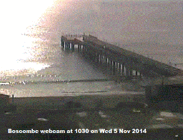
So far, my only way of guessing the "true" high water time, is by looking
at the
Boscombe Web Cam
- and using a little "common sense". e.g. effect of wind, etc. Anyone want to wade
in with a measuring stick ? :-)
At the time of writing this, we are still checking the accuracy of information on this page, and linked sites,
and what effect these have on any manual method we may suggest here, in the future.
Robin welcomes being contacted, via his "Contact" page above, if you see any
corrections that could be made to this page. e.g. the actual time of high water
between Boscombe and Bournemouth Piers, compared with what MagicSeaweed says.
e.g. the relationship of this "true" high water time, and the times of "slack water"
- when the tidal current changes direction.
So far, my only way of guessing the "true" high water time, is by looking
at the
Boscombe Web Cam
- and using a little "common sense". e.g. effect of wind, etc. Anyone want to wade
in with a measuring stick ? :-)
After we get these "basics" validated, such as the relationship of the following TotalTide images, to an easy to find "high water time", we can simplify our launch strategy down to launching within a particular "time window" of high water. e.g. suppose we said "launch three hours before Portsmouth high water", that would equate to about 1400 in the TotalTide images below. The boat might take one or two hours, to get away from the coast, and into a much stronger tidal current. By the time it gets that far, the boat is heading into "slack water", that then turns, taking it west, and away from the Isle of Wight. For now, I've included both Bournemouth and Portsmouth, in the labels below, even though Bournemouth is more complicated, having a "double tide".
For simplicity, I've approximated the "HIGH 12:50PM" from MagicSeaweed, as 1300, so that the images below can be used as a rough guide to tidal current direction. e.g. the first, for 0700, is labelled "0700 on 15 Oct 2014: 6 hours before high water at Bournemouth , and about 10 hours before High Water at 1715:".
A "Cloud Backup" of Robin's old TotalTide installation CD is in totaltid.zip .