

Home
GPS
Download
Business
Partners
Contact
Family
AVL
Links
History
AsOnTV
UK DOWNLOAD PAGE
Updated 0930 Friday 5th November 2010 UK Time
Do NOT run these downloaded EXE from your Internet browser.
Put them in the GPSS folder then run from file Explorer to add the files.
Some UK mapping is already included in the GPSS Baseline,
downloaded by all users - wherever you are in the World.
Here is UKWAW.EXE
download which self-extracts into a much bigger
GPSS.WAW with 218 supporting WAV files, to support
spoken description of position and Ctrl-A Reports within the UK.
This was updated in August 2006 to make it faster on the
Pocket PC (UK grids changed to lat/lons).
DOWNLOAD UKWAW.EXE (1,324,403 bytes)
Here is UK99MAPS.EXE which self-extracts into
41 maps, each nearly 99 miles across, covering All UK.
The maps are not as detailed as many, but show major
towns and roads, together with information 'spoken' by
GPSS for many years: petrol stations, eating places -
such as 'Little Chef' and 'Happy Eater' sites, and Interesting
Places such as National Trust and English Heritage sites.
DOWNLOAD UK99MAPS.EXE (744,871 bytes)
SPEEDUK.EXE below provides speed trap warning data for the UK.
See the speed page for details,
including how to update with the very latest data from www.PocketGPSWorld.com.
DOWNLOAD SPEEDUK.EXE (364,332 bytes) updated November 2010.
UKSOUNDS.EXE below, includes 186 WAV file sounds from the original 1995 'full product'
which were stripped from the GPSS Baseline to save space. They include
support for less common categories of place.
DOWNLOAD UKSOUNDS.EXE (1,132,869 bytes)
 Most people in the UK using GPSS download UKWAW and UK99MAPS
above, then visit the
AutoRoute/Trips page, download ARED, and make
GPSS-compatible street level mapping from Microsoft CDs. You may also find out how to create your own mapping
for GPSS by visiting the
addmaps page - including using free aerial photos from
Getmapping (picture on right), or google earth via the
mapimage
page.
old UK download page material
from November 2001
Here is the very old LONDONBA map, covering the inner London area,
that has been in the GPSS baseline since 1995. We are removing it,
into this seperate LONDON.EXE download, to make room for other
things in v5.2 of GPSS. Maybe in the future we will upgrade this
LONDON.EXE module to something better.
DOWNLOAD LONDON.EXE (142,396 bytes)
Here is alternative mapping to the '99 mile' maps above.
These are the '100 mile' maps, produced in collaboration with
ESR Cartography
when GPSS was first launched in the UK in 1995. They are available
as three floppy-disk-sized downloads, for Scotland, the North,
and the South of England. If you load both '99' and '100' mile maps,
you will need to zoom out (Z key) to see the '100 mile' maps.
DOWNLOAD UK100SCO.EXE (1,450,221 bytes) Scotland '100 Mile' Maps
DOWNLOAD UK100NOR.EXE (1,341,586 bytes) The North '100 Mile' Maps
DOWNLOAD UK100SOU.EXE (1,333,984 bytes) The South '100 Mile' Maps
Some of you may wish to use GPSS with low cost street level mapping.
One of the better solutions is Microsoft AutoRoute Express 2000
using the ARED Driver explained on our
AutoRoute Page
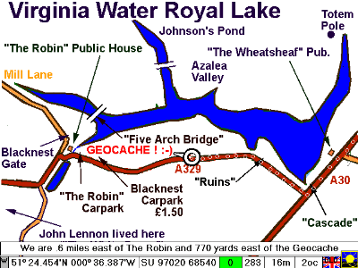
Virginia Water Geocache Map
Here is the mapping download which
provides the Virginia Water Royal
Lake map to support the
GEOCACHE page.
A demonstration is in VWATER.NME
DOWNLOAD VWATER.EXE (66,217 bytes)

The information below has been on this page
for some time.
London Street Plan Mapping from Bartholomew
 Bartholomew have given permission for a sample of their
1:5,000 scale, London street plan mapping to be released for demonstration and test with GPSS . The links below will enable you to download the data and run a demonstration 'on the desk', based on recorded GPS data. If you are within travelling distance of the location, you may want to test it out 'on the road'.
Use GPSS Version 4.7 and then Download the data
We assume you are already running the 4.7 baseline copy of GPSS, or a later issue, downloaded off this site.
We suggest you at least run GPSS 'on the desk', to check it is working, before
you then download the London Street Plan sample, by clicking on the link below.
As for most downloads, the self-extracting file should be downloaded into
the C:\GPSS04 directory, with the other GPSS software, and run to extract the files.
IMPORTANT : You will also need to create a new directory C:\5KSAMPLE and
copy or move the four BMP files into it. All other files should remain in C:\GPSS04.
DOWNLOAD 5KSAMPLE.EXE (617,746 bytes)
To run the demonstration 'on the desk', hit Control-A, then double click on 5KSAMPLE.NME followed by REPLAY. To use it 'on the road' - just go there with your GPS and PC running GPSS :-)
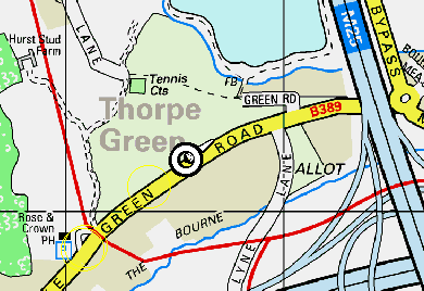
The sample mapping is around Virginia Water, south west of London
The sample chosen is on the south-western outskirts of London - or as GPSS may say "we are 19 miles west of London and 1.1 miles east of Virginia Water". The sample extends over an area of 5 km x 5 km, with the Chobham 'Tank Factory' Defence Establishment in the south-west corner at SU975650, and Thorpe Industrial Park in the north-east corner at TQ025700. The A30 and Virginia Water lake lies in the north-west corner
and the village near the centre. The main M25/M3 junction is in this area.
Some technical stuff about GPSS use of this mapping
This street plan mapping is in one of the 'tiled' formats supported by later versions
of the GPSS software. A good 486 with at least 8MB RAM is the minimum performance needed to handle this data. GPSS can be configured to pan the map continuously under the car position - so the car remains in the centre. To see this, edit
GPSSTILE.CFG and change the parameter to 1. This is the distance that the car moves before the map is automatically re-centred. Examination of the 4 BMP files will show that each is 1000 x 1000 pixels, and covers an area of 2.5 km x 2.5 km
i.e. 2.5m per pixel. The name of the BMP file is based upon the UK grid reference.
i.e. 49751650.BMP has its south-west corner at SU975650. The coverage of the
a rectangular patch of tiles is described in a single DES file, 5KSAMPLE.DES.
Where do I get this mapping ?
For more information about the Bartholomew 1:5,000 street plan mapping,
you may contact Duncan Pickering at Bartholomew on tel. 01242 258134
fax. 01242 222725. You may also contact Robin Lovelock, of course.
Note that the mapping must be in the above format to work with GPSS.
Waypoint Data for use with GPSS or just Garmin
John Seymour has over 5000 GPS waypoints for UK on his
Waypoint Website
- which can be converted to GPSS GTX format by use of WPT2GTX.EXE
DOWNLOAD WPTGTX.EXE from alternative site (35,065 bytes)
WPTGTX.EXE self extracts into WPT2GTX.EXE at 43,040 and WPT2GTX.BAS
New GTX files, such as $FSS.GTX should be inserted into GPSS.FND
Ordnance Survey Interactive Atlas of Great Britain
This CD-ROM is one of the lowest cost available (Robin purchased his copy at 30 GBP inc VAT, and free copies were given away on Nov 98 PCW). It includes good mapping of the UK
down to 1:250,000 (road atlas) detail. This will run under both Windows 95 and other Windows systems such as 3.1 or 3.11. The CD-ROM was produced by Attica
Interactive Ltd, using Ordnance Survey copyright data.
You will find it a simple process to import maps into GPSS from this CD :
- Run 'OS Atlas' and familiarise yourself with controls.
- switch readout to Grid. e.g. SU123456 format.
- select scale of map (e.g. 1:250,000) and area.
- use Control ^ button, so map covers all screen.
- move mouse to low left corner and note grid ref (e.g. SU767553).
- move mouse to top right corner and note grid ref (e.g. TQ082799).
- use 'Print' and 'Save to File' into c:\gpss04. (e.g. MYMAP.BMP).
- Make sure you have notes (e.g. SU767553, TQ082799, MYMAP.BMP).
- Repeat for other maps and/or exit from 'OS Atlas'.
- Use your notes and GPSS to calibrate the maps.
The calibration process is documented on ADDMAPS.HTM, but in summary :
- Add MYMAP into the list of maps held in MAPS.DIR using Edit.
- Run GPSS - it will detect this is a new map, and display the map image
with instructions for you to enter information such as the name and
coordinates of two reference points in low left (south west) and top
right (north east) corners.
- Click on the two points.
- Enter their location into the two boxes provided (see below ref 200m error)
- Click on the button labelled 'Lat/Lon' to switch it to 'grid'
- Click on the OK button.
- GPSS will create a file, MYMAP.DES, that describes the map. Next time
you run GPSS, the new map will be included with the other maps. GPSS
automatically selects the appropriate map under the car position.
200m error : we recently found an error of about 200m, in the north south direction,
displayed by the product. This was discovered using GPS, but then confirmed
by comparing grid readouts with O.S. Landranger 1:50,000 paper maps. We understand the error was on the source 'Strategy' data supplied from O.S. to Attica. But the solution is simple : simply apply the 200m correction
when you enter the grid locations. You must add 200m to the northing.
e.g. SU983686 displayed by the Attica software should be entered as SU983688.
e.g. SU983689 should be entered as SU983691.
Pointing on the map within GPSS, or tracking something with GPS, should then
be more accurate.
Mapping for the Channel Islands
These 3 maps and 23 sounds cover the Channel Island region, and are for use
by Colin de Conte, his friends, and anyone else with GPS in the area. PLEASE NOTE THAT THE DATA STILL HAS IMPORTANT INFORMATION MISSING - such as rocks - and so should not be relied on for safe navigation at sea. A desktop demonstration is available under Control-A CHANNELI.NME REPLAY, and it will work for real with GPS.
CHANNELI.GTX can be copied to GPSS.GTX and $LPOP.GTX. It holds the locations of 3085 population centres in the region, accurate to about 1 mile - but the names of places in the Channel Islands are those appearing in the US Govt data source - not in UK use.
DOWNLOAD CHANNELI.EXE from alternative site (201,732 bytes)

 Most people in the UK using GPSS download UKWAW and UK99MAPS
above, then visit the

