
Home
GPS
Download
Business
Partners
Contact
Family
AVL
Links
History
AsOnTV
OZIMAP for GPSS in Australia
0900 Wednesday 15th March 2006

Home
GPS
Download
Business
Partners
Contact
Family
AVL
Links
History
AsOnTV
OZIMAP for GPSS in Australia
0900 Wednesday 15th March 2006
 Most of the information on this page is unchanged since it was updated
in October 1999, after OZIMAP was first made. Over the years it has been
used by a handful of people in Australia, and a few other places like
Denmark, to break up a large bitmap map image into a number of overlapping
GPSS-compatible maps.
In the longer term the whole page may get a re-work, but for now I'm just adding this information at the front for those few who want to help test, and perhaps use, the very latest version of OZIMAP. This new version was done in collaboration with Stewart Little in Oz, who suggested I extend OZIMAP to cope with the Mosaic format bit maps, which seem to differ from the AUSLIG ones in not having the map sheet border around the edge.
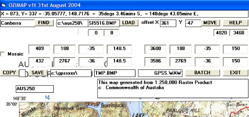 This latest version should still work with the original AUSLIG files,
available since 1999, but has more control over the process which rotates
and chops up the big BMP image. At the time of writing, OZIMAP v1t seemed
to work OK for all AUSLIG files and some of the Mosaic files including Canberra
- but not others such as Sydney. The FIND button reads the appropriate line
of parameters based on the entered name from file AUS250.TXT. These include
the four x,y pixel to lat,lon reference positions used to rotate the map.
If the Mosaic checkbox is ticked before the FIND, these x,y parameters are modified.
Those wishing to experiment may be able to get properly calibrated maps
via the user controls - and if we see a pattern we may be able to update
OZIMAP to do this automatically for all the source maps. I understand that a new version of the AUSLIG
CD will be released within a few months, so hopefully this will still work
with OZIMAP.
You may download the latest set of OZIMAP files, compressed into
ozimap1t.exe
You will also need, of course, a CD of source mapping. e.g. that from AUSLIG.
Many Thanks for your help - particularly Stewart Little, Steven Janda and
Brian Sommerville.
Let's hope it is not another five years before I update
this page :-)
Robin Lovelock
September 2004.
from Robin in October 2005: not much to add, other than this tip: if you get strange symptoms like blank maps being produced, perhaps related to lack of memory on the PC. Try reducing the number of colours to 256 in the big BMP file, with something like Windows Paint.
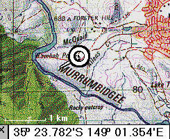 Hi ! You must be one of the very few who know about this page - barely
yet public. It has been set up to assist communication between myself
and those testing OZIMAP - or with a direct commercial interest. The majority
of testing has been done by Steven Janda, south of Sydney, who alerted me
to the 1:250,000 RASTER product for Australia. Graham McCann in Canberra
was an early 'Ozi' contact of mine, and got into the nitty gritty of GPSS
over two years ago. He also made contact with AUSLIG to obtain permission
for the samples of AUSLIG and Universal Press copyright mapping to be made available as
downloads from this web site (see the 'History' section at bottom of this page).
I hope this information, and the OZIMAP software,
will soon be available for a wider audience, so that good GPSS-compatible
mapping is available for Australia, in the same way as it is now for the USA,
UK and Europe with the
Microsoft CDROMs
Robin Lovelock
October 1999.
 There is a fuller description of the RASTER 250K product on the
RASTER 250 page of the
AUSLIG Web Site,
including prices, ordering information, etc.
7 CDROMs are available covering all Australia, at 550$ for the lot, or
99$ each. There are 550 source maps in total, each covering 1 degree in
Latitude, and 1.5 degrees in Longitude. i.e. 110km x 130km. Software is
included on each CDROM, called RASTER.EXE, which supports finding of the
correct map image - in compressed TIF format - and downloading it in alternative
formats - including BMP recognised by OZIMAP described below.
 It is possible that OZIMAP/GPSS will have a 'Baptism of Fire' in a few days
- if Steven Chew from Singapore manages to buy and get
his CDROMs in time.
 He leaves Singapore this weekend for Darwin, as part
of the Singapore Polytechnic
Sunspeed Solar Car
Team.
Robin put up this page on Friday 1st October, and Steven contacted Robin
within hours. He didn't know about this page - but he does now :-)
OZIMAP is a little program which generates GPSS-compatible maps from the 1:250,000 RASTER Product. It is only a few days old, and is still experimental. However, it already seems useful. We hope to improve it further in the coming days.
The picture below shows an early version of OZIMAP in use.
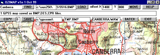
The map image is Commonwealth Copyright, and from the RASTER 1:250,000 product.
Steps in using RASTER.EXE, OZIMAP.EXE and GPSS.EXE are as follows:
Robin would greatly appreciate your help in testing OZIMAP and GPSS.
Here are the steps for those helping Robin with testing:
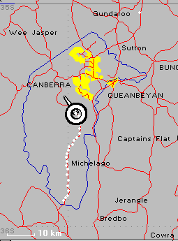
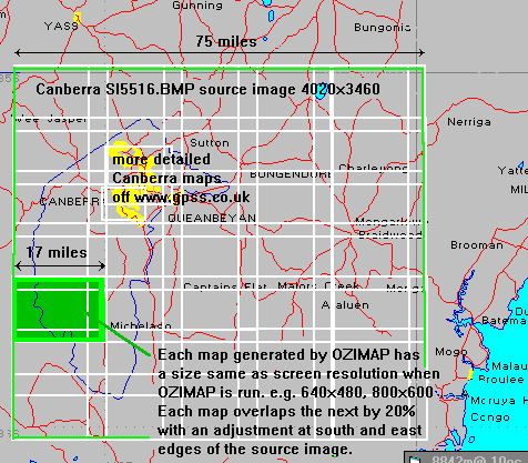 The picture on the left is based on that using the `showmaps facility in GPSS.
It shows the typical coverage of each source BMP image
(in this case Canberra SI5516.BMP) and the coverage
pattern generated by the OZIMAP BATCH process. Tests done indicate
good matching with the more detailed Canberra maps off the web site.
You may also want to test the UTM grid readout of GPSS, by hitting Control-U
on the keyboard, then pointing with the mouse at grid lines.
 This tells you about what little Australian mapping is already on
this web site - for download and testing with GPSS - and the sources.
First the picture on the left: this shows the typical (low) detail in
mapping first uploaded for Austalia, onto this web site, based upon
American Public Domain sources, such as the 'Digital Chart of the World'
(DCW) set of CDROMs. This mapping is 'better than nothing' and is often
the first (sometimes the only) mapping uploaded for use with GPSS in a new
country. At the time of writing this, there are now 112 countries in which
people are using GPSS with a GPS receiver - and all are supported to some
degree, by mapping on this web site. In the past year, the offline software
used to generate this mapping from the DCW CDROMs has been improved, so you
will find more recent countries done, like Brazil, to have better coverage than
Australia. We could upload more of this mapping - but there seems little
point now - since better quality mapping is becoming available in the right
form from other sources.
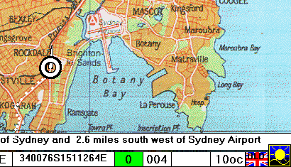 Where possible, when we have permission
from the copyright owner, we upload more detailed mapping. Samples are
chosen to be in the same area as our 'GPS contact' so they may be tested
'for real' with a GPS receiver. The more detailed mapping sometimes requires
to be calibrated against WGS84 lat/lon, and our 'enthusiast' contacts are
often the first to help us with this. The sample on the upper-right is copyright
of Bartholomew, and typical of the mapping from 'The Times Atlas' also
uploaded over two years ago.
 As mentioned earlier, one of the first GPS contacts in Australia was Graham McCann
in Canberra. The sample on the left is Commonwealth Copyright and from the
ACT 1:100,000 sample of Canberra which AUSLIG gave us permission to make available.
This was in return for the detailed credits on the Australian download page
and the copyright message which appears whenever GPSS retrieves the map.
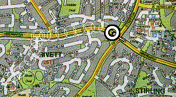
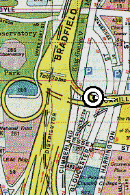
This mapping was calibrated against WGS84, and assisted us in then adding
more detailed mapping, such as the 1:25,000 extracts from Universal Press
Pty Ltd that you see to the right.
 Permission from AUSLIG was to scan and use a particular map sheet. Further
extracts would require additional permission. The agreement with Universal
Press did not have this restriction, so we could have scanned and uploaded
a much better selection of samples. However, compared with the USA, UK,
Europe and Asia, there has been comparitively little business-interest in GPSS
within Australia.
 This has limited effort in scanning, calibrating and uploading additional Australian mapping.
Uploading samples is also a short-term measure, less important when suitable
low cost CDROMs become available.
We then simply concentrate on making sure
these can be used with GPSS, and that people know where to get them.
Perhaps the AUSLIG RASTER250K product may be the first to be made
available at the right price. Some may take the view that 99$ is already
good value for money for many applications. However, this should be
compared to other countries, where more detailed mapping is available
at lower costs - because it is sold in greater quantity. It is not
only the USA - where Government mapping is copyright free - and 25$US
purchases good street level detail for all the USA:
examples of low-cost GPSS mapping are available for UK and Europe - such as the
Microsoft CDROMs
 I'd like to take this opportunity to thank those who
have helped with this work. I've already mentioned the
roles of AUSLIG, Universal Press, Graham McCann and Steven Janda, but others
have recently helped by providing information that has
saved time. In particular, I would like to thank Brian
Sommerville, who has given permission for me to download
the Raster 250k .dat files off his web site, and process
them into the format needed within AUS250.TXT. Since Brian
is more closely associated with OziExplorer - an alternative
GPS Software product to GPSS - this is particularly refreshing.
Perhaps the best way to end this page is the picture below, from Steven,
used on our
4x4 Page
set up for the Trans-Libya 4x4 Expedition earlier in the year.

above picture based on that from Steven Janda in Australia, who can be contacted via the
GPSS Links Page