
Home
GPS
Download
Business
Partners
Contact
Family
AVL
Links
History
AsOnTV
Trans Libya 99 4x4 Rally

Home
GPS
Download
Business
Partners
Contact
Family
AVL
Links
History
AsOnTV
Trans Libya 99 4x4 Rally
The map on the right is from Oscar, showing the route.
Please do not abuse the fact that you may contact these people.
Robin only speaks English, but you may contact him on
gpss@compuserve.com
You may also contact others who speak Portuguese or Spanish.
Jose Ramos, a 'GPSS Expert' may be contacted on
jose.ramos@mail.telepac.pt. Jose is in Lisbon near 384800N0091140W, and has a Garmin 12XL. Jose sells Garmin cables, details of which can be seen on
Jose's Garmin Cable Page
Jose is Portuguese.
Oscar is a new contact of Robin, but we hope to include more detail here soon.
Oscar owns a chain of shops which, among other things, sell Garmin GPS systems, and may be
contacted by email on
sottaventura@mail.telepac.pt
Oscar is Spanish and will be on the Trans Libya 99 expedition.
The GPS Software should be downloaded and tested with your GPS and
cable, before you add the maps for Spain, Portugal, Tunisia or Libya.
You should contact Robin by email, with answers to 'Quiz Free Registration'
on the same
GPSS Download Page to get a free 'Snoopy
Suppression' key, more data, and technical advice. Robin may be able to
put you in touch with someone already using GPSS near you, who speaks
Spanish or Portuguese.
If you wish, Robin will also add you to the
GPSS Links Page and this page. The more people
who help test GPSS and new mapping - the better.
You should learn how to use GPSS now - before you leave Spain or Portugal.
You will find GPSS mapping for Spain and Portugal on the
European Download Page
Mapping is available for Tunisia and Libya on the
African Download Page
This page is being used to make sure there is a common understanding
on basic information such as the approximate route, and the locations of relevant waypoints.
Robin can e-mail you other data, such as waypoints provided by Oscar,
processed into GPSS-compatible form.
Robin can e-mail the whole file to those who contact us with Quiz Answers.
This data has been processed into two files: TL99.GTX suitable for being searched
and used to select the next waypoint as the destination. TL99.NME suitable for
being 'played back' or plotted - to produce the picture on the left, with the
GPSS Control-A DRAW facility. NOTE: the waypoint number
(e.g. 0001) may be different between files. You would normally only use one waypoint
GTX file.
It is best to have learned how to use GPSS before you start the expedition,
using mapping for your home area of Portugal or Spain.
1. first test GPSS works with your GPS connected, and contact Robin by email
to get a 'Snoopy Supression' code. You will need to send your quiz answers.
2. learn how to use the simple facilities in GPSS:
At present the TUNISIA.WAW and LIBYA.WAW files, used to say where you are
relative to major cities and small villages, are very big (thousands of villages), and
may be a little slow on some older Laptop PC. If you have this problem, contact Robin,
who can provide a smaller WAW file, that will not include the small villages.
b. searching a GTX file and use of D key to select a destination. looking at the
Instrument Panel switched on with _ key, and listening to voice guidance.
You may also want to put the most important 10 destinations into GPSS.LOC,
so you can select them with 1D, 2D, etc.
If you are VERY CAREFUL, and you have the time, you may wish to create
suitable ROO files, for automatic change of destination, but this requires
the data to be exactly correct. So it may be best, simply to use the facilities above.
But for those that need to know, here is some information about ROO files.
Route files can have a maximum of 100 waypoints. They must be accurate - i.e.
to within GPS accuracy of 50m to 100m, or better. They must be in the correct
order. i.e. the first waypoint first. When using ROO files, you must drive to within
typically 50 metres of a waypoint in the file, to cause GPSS to automatically select
the next waypoint as the destination - for the Instrument Panel, and voice guidance.
The above are reasons why it is often best not to use ROO files: Easy to make mistakes.
Here is the start of the 99X.ROO file illustrated in the pictures above:
The *R150 at the end of the line, is the Threshold Range in metres, used by
GPSS to automatically switch the destination to the next waypoint. 150m is
a practical value, for use with a normal GPS - which is only accurate to typically
50m to 100m. Making this a bigger value, such as *R500 means less accurate
data can be used, but it means the automatic switch of destination will happen
earlier. e.g. when you are 500m from the waypoint.
Robin can e-mail data in the format needed for a ROO file, as TL99ROUT.TXT
BUT THIS MUST BE BROKEN INTO SMALLER ROO FILES with the correct
sequence of waypoints. If others create these files, they may be available.
To use a ROO file, it must be copied to GPSS.ROO. This could be done
with a number of little .BAT files, with Icons on the Desktop, each with a
simple command like "copy 99roo1.roo gpss.roo". To select that route,
you would then double click on that icon.
But then you must make the Route Guidance in GPSS active. To do that
you hit Control-C, click on the RouteMan button, to get the Route Manager.
You then click on READ to read GPSS.ROO and display the route on the map.
You can then switch on (or off) the automatic Route following.
But Robin stresses - you do not need to use this. Maybe much easier to
use the simple facilities described earlier. i.e. manually select a 'final' destination
for that particular journey, from a GTX file.
Please do not forget that GPSS and all this data is used at your own risk,
Take Care & Safe Travelling.

above picture based on that from Steven Janda in Australia, who can be contacted via the
GPSS Links Page
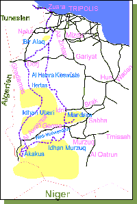
 This page is in support of the 'Trans Libya 99' 4x4 event, to be held soon.
Over 22 participents from Portugal and Spain will be navigating across desert
terrain in Tunisia and Libya. Jose Ramos, the 'GPSS Expert' in Portugal, put
Oscar Hernandez in contact with Robin. First email contact was only Monday,
8th March, but rapid progress has been made. Robin is very grateful to all those
who are helping to ensure that reliable and accurate mapping is available
in time for free use by all participents who wish to use GPSS - if only to
see where they went when they got home.
Contacts
Downloading the GPS Software and Mapping
Waypoint Data
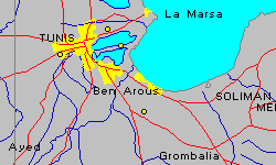 Oscar emailed Robin a Waypoint+ TXT file late Tuesday 9th March (saved as OSCAR2.TXT), and
Robin received answers from several contacts on this file format (e.g. latitude
of 35.1234567 means 35 degrees 12 minutes 34.567 seconds). Software has been modified to convert the TXT file into various forms, including
HTML text appearing below, and a NME file suitable for 'playback' on the GPSS maps.
The first picture on the left shows a plot of the first waypoints near Tunis.
This is typical of the minimum detail of the maps covering all Tunisia and
Libya that you can download. The downloads also include the approximate locations
and names of several thousand villages in each country.
Here are the first three points of the waypoint data:
Waypoint = Lat/Lon (degs,mins,secs) = degrees = GPSS(15 character) =  Name
1=36°48'56.05"N 10°15'56.73"E=36.81557 10.26576=364893N0101594E=PORTO DE TUNIS
2=36°47'48.91"N 10°06'51.47"E=36.79692 10.1143=364781N0100685E=PONTO CONTROL
3=36°40'37.28"N 10°19'30.29"E=36.67702 10.32508=364062N0101950E=PORTAGEM
Here is the same data, converted into a GPSS-compatible TLIBYA99.GTX file:
TLIBYA99.GTX holds waypoints for Trans Libya 99 Event
cat,,location,name,  - note these two lines are comments
L,,364893N0101594E,0001 PORTO DE TUNIS,
L,,364781N0100685E,0002 PONTO CONTROL,
L,,364062N0101950E,0003 PORTAGEM,
Please see the 'Quiz Free Registration' section on
the first Download Page
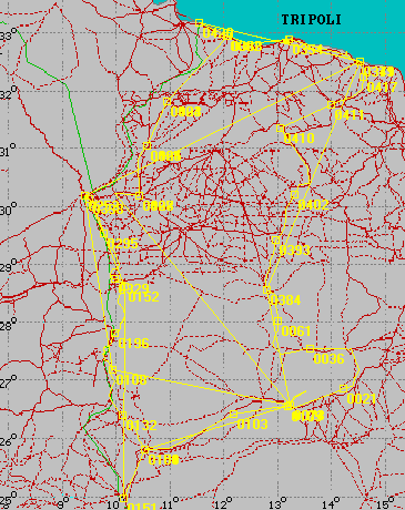 The picture on the left shows a plot of waypoints in the area of the event, based
on the ordered list of route waypoints e-mailed by Oscar to Robin on Saturday 13th March.
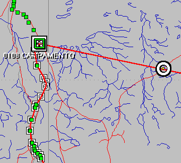
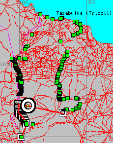 The map on the left shows a plot of waypoints (in green) and a selection
of wayoints to make a Route (ROO) file (in red). The picture below shows
some of the same information, as shown on the more detailed Libya mapping you can download.
Use of GPSS
a. looking at the map, and use of W key - to get 'Where are we ?' response.
Route Files such as 99X.ROO
 45
263395N0131536E *R150
271085N0095694E *R150
271025N0095640E *R150
270917N0095574E *R150
270863N0095544E *R150
etc.
The first line is the number of waypoints in the file. This must be 100 or less.
Then each line holds the GPSS format 15 character lat/lon, in degrees, minutes,
and 1/100ths of minutes. e.g. 263395N = 26 degs 33.95 minutes North.
PLEASE DO NOT FORGET
and is no substitute for good paper maps, a compass, and navigation skills :-)