Home . GPS . Download . Business . Partners . Contact . Family . AVL . Links . History . AsOnTV . Forum
New v6.97 GPS Software Baseline
Updated Tuesday 22nd November 2011 UK time
Home . GPS . Download . Business . Partners . Contact . Family . AVL . Links . History . AsOnTV . Forum
New v6.97 GPS Software Baseline
Updated Tuesday 22nd November 2011 UK time

 I have just released the latest GPSS Baseline - version 6.97 November 2011,
which includes v14 of GPSSppc for the
Pocket PC. The
brief user manual for GPSSppc is
here
and GPSSppc change history on the
beta testing
page.
The GPSS change history, including during 2011, is on the
oldnew
page.
I have just released the latest GPSS Baseline - version 6.97 November 2011,
which includes v14 of GPSSppc for the
Pocket PC. The
brief user manual for GPSSppc is
here
and GPSSppc change history on the
beta testing
page.
The GPSS change history, including during 2011, is on the
oldnew
page.
The "GPSS Baseline" is the GPSS.EXE and GPSSPPC.EXE programs, with the minimum mapping and sound files needed to make the programs work. These are in the small GPSS.ZIP download on the download page.
The GPSS Baseline changes slowly: we only update it every year, or every few months. This is after many users have "beta tested" the very latest versions of GPSS (for full Windows) and GPSSppc (for Pocket PC).
This page gives some history on GPSS Baselines, and was first set up over ten years ago.
Please contact me for free support using step 2 on the download page, after you have GPSS responding to the GPS (step 1). The more who contact me, the quicker I can correct any bugs, improve documentation on this web site, or introduce new features in the pre-release copy of GPSS being prepared for the next GPSS Baseline.
Most of the changes to the GPSS Baseline in recent years were improvements in the Pocket PC version, addition of a few specialist features, and - of course - correction of bugs.
The September and April 2008 GPSS v6.91 Baselines included support to ARP and TBTG and minor bug fixes. The February GPSS v6.9 Baseline gave a few improvements in the full Windows GPSS.EXE including better handling on unusually shaped bitmap maps and the experimental LINKMAN facility.
The GPSS v6.8 Baseline, uploaded in November 2007, included a better demonstration of facilities in both full Windows GPSSS and Pocket PC version, including "more information" pictures and recorded sounds. Sample pictures and sounds are included for places such as Sunninghill, Ascot, Virginia Water and Stonehenge. These samples are to assist Solution Providers and enthusiasts experimenting with this capability.
GPSS v6.7 was released in September 2007, and included GPSSppc v7.
GPSS v6.6 (July) fixed one or two very old bugs, improved support for ballooning, and introduced support of iTrac hardware. GPSS v6.5 (June) included GPSSppc v5. GPSS v6.4 (April) fixed a very old bug related to non-English language, and coped with an old Windows 98 Microsoft bug which surfaced in Windows Vista. The detailed change history for GPSS is on the oldnew page. Mapping is compatible for both GPSS and GPSSppc, but this page talks about the full Windows GPSS.
I would like to thank Marty Brilliant, in New Jersey USA, for his
invaluable help with the upgraded USA street mapping released in late 2005
to replace that first made available here in 1999/2000.
 For details of use please visit the
usadown page.
This was a major update,
including water, railroads and landmarks such as railroad stations, airfields, churches and schools.
For details of use please visit the
usadown page.
This was a major update,
including water, railroads and landmarks such as railroad stations, airfields, churches and schools.
Some old features have been improved and a few new ones added:

 The vector mapping used to provide free street maps over all the USA remains unchanged,
but we have improved the bitmap (BMP image) handling to include automatic panning
of the bitmap image across the GPSS display, to follow the car's movement. This
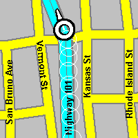
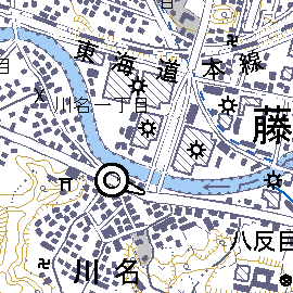
was done so that GPSS users in Japan would have access to the free street level
mapping covering all Japan. Details of this are on the
JapanMap page. This feature can be used for mapping
anywhere in the World.
Other improvements include the addition of "GG" type DES files, in addition to
"LL" type, to enable UK users to exploit free aerial photos and mapping more easily.
The vector mapping used to provide free street maps over all the USA remains unchanged,
but we have improved the bitmap (BMP image) handling to include automatic panning
of the bitmap image across the GPSS display, to follow the car's movement. This
was done so that GPSS users in Japan would have access to the free street level
mapping covering all Japan. Details of this are on the
JapanMap page. This feature can be used for mapping
anywhere in the World.
Other improvements include the addition of "GG" type DES files, in addition to
"LL" type, to enable UK users to exploit free aerial photos and mapping more easily.
Click here to see how you can add mapping into GPSS from other web sites.
 GPSS can now more simply handle data arriving from a second COM port.
This permits simple, off the shelf implementation of "chase mode", first
televised in UK nine years ago - see
AsOnTV page.
GPSS can now more simply handle data arriving from a second COM port.
This permits simple, off the shelf implementation of "chase mode", first
televised in UK nine years ago - see
AsOnTV page.
The GPS Engineering display, under the ^ (shift 6) hotkey, has been extended to handle the second com port. Two check boxes permit you to monitor data arriving from both or either port. The number of satellites available for calculation of the position is also shown on the instrument panel under the _ (underscore) hot key.

Robin in December 2005: the following old, but perhaps interesting, information, has been moved from the bottom of the "oldnew" page. It describes "new" features in October 2000.
 Hopefully this page will start to get a little more interesting,
with pictures showing some of the changes available for test.
The picture on the right shows the Instrument Panel in Version 4.94e
and later. New features include display of destination name and
the altitude information - including the slope of the road.
Guess I'll get the wife to drive, while we race up and down
some hills :-) Altitude units change to feet if you use "\" key
to switch from car to aircraft. When in "aircraft mode" a line
is maintained between your position and the destination.
Hopefully this page will start to get a little more interesting,
with pictures showing some of the changes available for test.
The picture on the right shows the Instrument Panel in Version 4.94e
and later. New features include display of destination name and
the altitude information - including the slope of the road.
Guess I'll get the wife to drive, while we race up and down
some hills :-) Altitude units change to feet if you use "\" key
to switch from car to aircraft. When in "aircraft mode" a line
is maintained between your position and the destination.
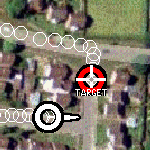
Improvements have been made to facilities shown in Control-C MVDEMO.
Double Clicking* on the "Vehicles Tracked" summary, or a vehicle icon,
will result in GPSS looking for TXT, WAV, and/or BMP files that
provide more information on that vehicle. e.g. click on 02 after
adding the sample data from $MV$02.EXE below. Also, incoming $GPTXT
coded messages result in more infomation, such as a WAW position.
* Now double click needed. Single click simply selects that vehicle.
Version 4.94g introduces the ability to search WAW files in the same
way that GTX files could be searched - giving an immediate benifit of
finding those major towns and landmarks in 135 countries. The WAW file
is now the default category of information searched by GPSS, and is also
selected if the - key is repeatedly hit. For example:
`as
- followed by Enter key will find the nearest place that starts "as"
(e.g. Ascot). Hitting Enter key again will find the next nearest
place starting "as" (e.g. Ashford).
The wild-card asterisk character * permits a different search:
`*ham
- will find nearest place that includes the text "ham" (e.g. Wokingham).
Hitting Enter again will find the next nearest place (e.g. Farnham).
Following the found place by hitting d key, will make this the destination.
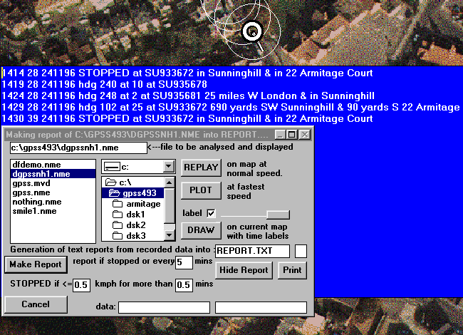
The picture below shows the greatly changed Control-A Analysis page. The very specialised facilities, originally developed for UK Police application, are now "tucked away" on the form. They become available if you maximise the form - but you will probably not need them now. The new "Report Generator" enables you to analyse a recorded journey, to detect where the vehicle stopped. The parameters can be controlled, according on whether you are looking for brief traffic delays or much longer "rest breaks". These are for our "remote tracking" users, but the "enthusiasts" may have fun with it. This picture shows the old DGPSSNH1.NME file from the Baseline being analysed. You can record your own NME files, for later replay and analysis, by hitting the % key. NME files are explained on the NME FILES Page